
Legga questo articolo in italiano.
Sloping land: investigations and comparing quotations
On this page
Start with the municipal planning office and an investigation programme defined by the designer. Italy’s technical construction standards, Norme tecniche per le costruzioni (NTC), require overall stability checks for works on or near slopes. A gradient percentage alone does not establish whether your house can be built.
In short
- Ask the Comune, the municipality, whether the local plan permits the proposed house before pricing foundations.
- Ground investigation must suit the works and affected ground; a map is not a geotechnical test.
- NTC requires overall slope stability assessment with and without works, including necessary cut and fill.
- TINITALY uses a 10 m terrain grid. It does not replace a measured survey of walls and small changes of level.
10 m
TINITALY grid
Model resolution, not site-survey accuracy.
INGV, TINITALY 1.1
§6.4.1
Overall stability
With and without works, including necessary excavation and fill.
NTC 2018
The report brings together public information about the land, with sources and dates, to prepare questions for the relevant offices: €29 in English or Italian · €39 in both languages · total, VAT included.
Read the gradient before comparing plots
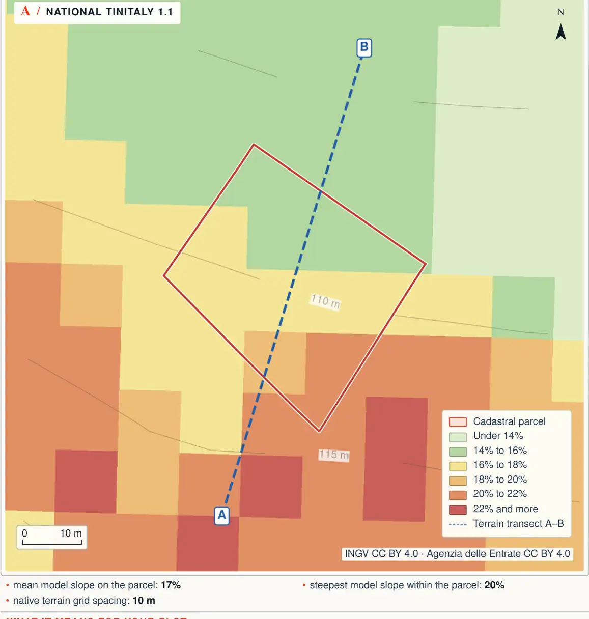
A 20% slope means a rise or fall of 20 metres over 100 metres measured horizontally. It does not mean an angle of 20 degrees. Ask the seller whether the listing quotes a percentage or an angle and whether it comes from a survey, a terrain model or an estimate made during a viewing.
A parcel can include a relatively level bench and a steep bank. Its average gradient may tell you little about the proposed house position. Likewise, a profile along the access road describes that direction, rather than necessarily the steepest direction across the site. Put the proposed building footprint and access on a drawing before asking for advice.
The Bagno a Ripoli sample reports a modelled mean slope of 17% and maximum of 20%, using a 10-metre terrain grid. These figures help prepare a site inspection. They are not construction survey measurements, and the grid cannot describe every small wall, step or change of level within the plot.
Establish planning feasibility before ordering structural design
Article 12 of DPR 380/2001 requires a building permit to comply with the planning instruments, building regulations and applicable planning law. A hillside that machinery can reach may still be unsuitable for your intended house under the local plan. Ask the designer to read the parcel’s rules before commissioning a complete structural scheme.
The starting point is the Comune, the municipality, and its planning department or SUE, the Sportello unico per l’edilizia building office. Supply the foglio and particella, the cadastral map-sheet and parcel identifiers, alongside a recognisable outline of the proposal. The guide to what you can build in Italy explains that initial document check.
Investigate hazard mapping and the vincolo idrogeologico separately. This is a soil and water protection constraint rooted in RD 3267/1923, not simply another name for a landslide map. Ask the competent authority which rules govern the proposed changes to this site. Its clearance should not be confused with the engineering assessment of slope stability. See the guides to hydrogeological constraints and PAI flood and landslide mapping.
- MunicipalityPlan and constraints for the proposed house
- Geologist and designerInvestigation, ground and stability with cut and fill
- ContractorEstimate for the works actually designed
Sources: NTC 2018, Chapter 6: slopes, investigation and foundations; DPR 380/2001, Article 12: permit requirements; RD 3267/1923, Article 7: changes to protected land; INGV, TINITALY 1.1: terrain grid and licence; Sardinia Forestry Corps: quotation of RD 3267/1923 Article 1; Decree of 9 March 2023: NTC amendments; accessed 13 November 2026.
What the investigation must establish
Italy’s NTC 2018 technical construction standards distinguish the geological model from geotechnical characterisation. The former explains the site’s setting and geological hazards. The latter supplies information about how the ground behaves in relation to the proposed works. The investigation programme must follow the design and the relevant volume of ground, rather than merely the surface area being purchased.
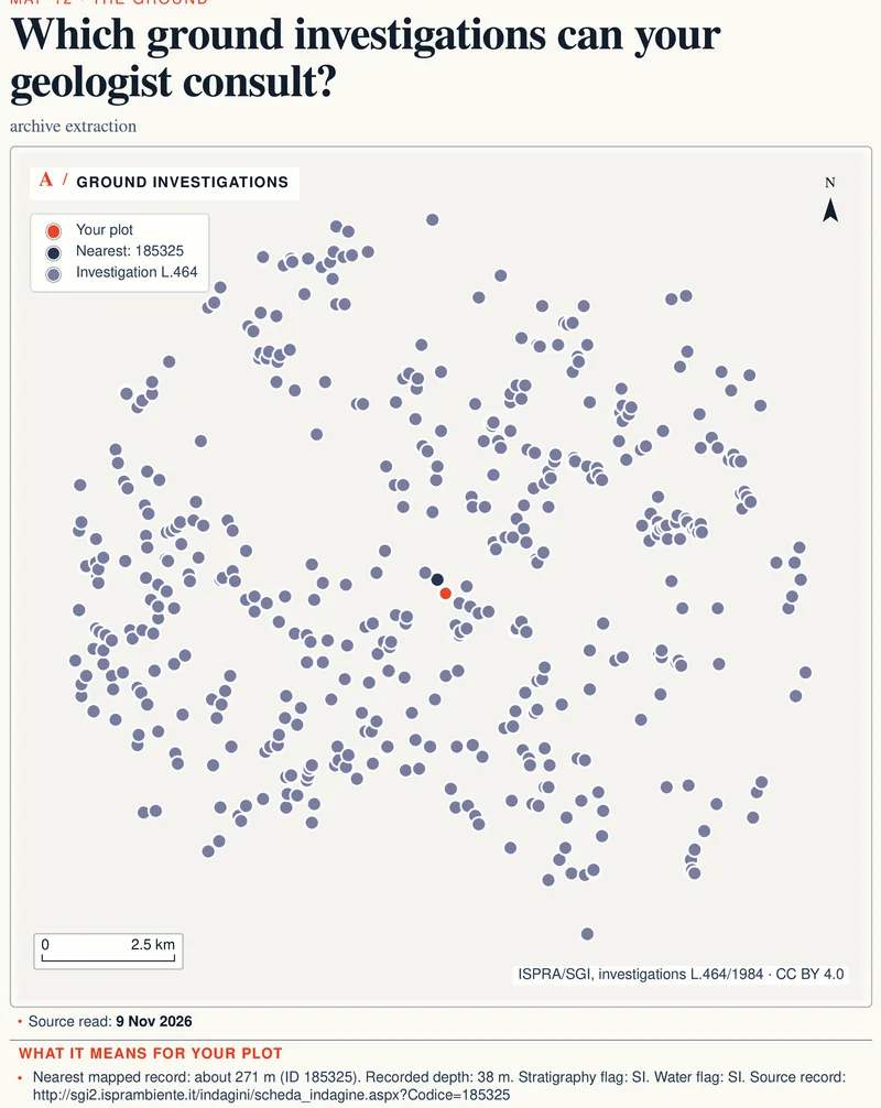
For natural slopes, section 6.3 calls for surface observations, the history of movement and hydrogeological information. Safety assessments must use data from specific geotechnical investigations. Ask the geologist to identify the information already available and the measurements still needed. A public borehole record nearby is useful background; it should not be described as a borehole drilled on your plot.
The appointment should identify the area studied, the deliverables and coordination with the structural designer. Agree when you will receive an initial assessment useful to the purchase decision and which findings might trigger further investigation. The separate guide to a geological report explains the documents without treating all professional tasks as the same service.
Foundations cannot be assessed apart from the hillside
Under section 6.4.1 of the NTC, works on or near natural or artificial slopes require assessment of overall slope stability both with and without the works. Necessary excavation and fill must also be considered. The question goes beyond whether a foundation carries the house: the designer must assess how the development affects the hillside.
Request a drawing with existing and proposed levels. If a platform is planned, it should show the cut and filled areas, the supporting works and the intended water routes. Ask how the temporary construction stages will be examined. The hillside will be altered before every permanent component is complete, so a drawing of the finished house alone does not explain the sequence.
| Component | Question for the appointment | Deliverable to request |
|---|---|---|
| Foundations | What ground will support the building? | Ground model and justified design choice |
| Retaining walls | Which levels and pressures were assessed? | Drawings and calculations for the proposed works |
| Excavation and fill | How does each stage affect stability? | Construction sequence and controls |
| Water | What water conditions enter the assessment? | Explicit assumptions and management arrangements |
| Access | Where will machinery and services pass? | Route and associated works included in the design |
This table helps define the commission. It does not prescribe a foundation or drainage system for every hillside; those decisions require site evidence and the appointed professionals’ judgement.
Compare quantities instead of adding a hillside percentage
Ask for an itemised estimate based on the same proposed solution. A general percentage added to the cost of a house does not show what the slope actually requires. Excavation, material transport, supporting structures and reinstatement should be identifiable wherever they differ between alternatives.
Use this comparison sheet to request two quotations for the same house position. It is a form to complete with the designer and contractors, rather than a price list. For each solution obtain drawing-based quantities, unit rates, totals and inclusions. Keep an undesigned item open instead of assigning it a generic allowance.
| Item to price in both solutions | Quantity evidence | Scope to match between quotations |
|---|---|---|
| House and access excavation | Cubic metres separated by specified ground and work type | Plant, access conditions, water and temporary support |
| Excavated-material transport and destination | Volume or mass, route and destination | Loading, distance, handling and any excluded charges |
| Designed retaining works | Wall dimensions, materials and foundations | Excavation, structure, drainage, reinstatement and construction-stage safety |
| Final slope works | Project surfaces and levels | Fill, water management and specified finishes |
Compare totals only after the designer confirms matching scope. Moving the house might reduce excavation while adding a retaining wall: have both changes priced. The difference then concerns the documented alternatives, rather than a supposed average hillside premium.
Ask what the unit rate includes and which drawing supports the quantity. Two contractors may quote the same rate but include different work. Obtain separate written fees for investigation and professional design. Ask the office receiving the application for its current administrative charges, rather than importing a tariff from another municipality.
The programme needs the same care. Agree delivery dates with each professional and ask who books the fieldwork or laboratory work. An estate agent’s suggested completion date is not evidence that the necessary investigations or administrative procedures can finish by then. Put any dependency on access to the land into the arrangements with the seller.
Sources: NTC 2018, Chapter 6: slopes, investigation and foundations; DPR 380/2001, Article 12: permit requirements; RD 3267/1923, Article 7: changes to protected land; INGV, TINITALY 1.1: terrain grid and licence; Sardinia Forestry Corps: quotation of RD 3267/1923 Article 1; Decree of 9 March 2023: NTC amendments; accessed 13 November 2026.
Four stages before committing to the land
- Before the offer, with the Comune and designer: establish the planning designation and relevant constraints. Ask the office for the procedure, document charges and response timing applicable to your request.
- At the technical inspection: identify the house position, access and survey area. Agree the date for the measured survey and preliminary findings with the appointed professional.
- Before a firm construction price: have the designer define the investigation programme and alternatives. Obtain fieldwork and report dates from those undertaking them.
- Before a binding commitment: compare the purchase price with documented project expenditure. Take unresolved checks to the notary so the contract can identify evidence, deadlines and consequences.
If the seller must permit intrusive investigation, settle that access before fixing the report deadline. The professional needs to know when entry is possible, which areas are available and what existing records will be supplied. An accepted investigation quotation is not the investigation’s conclusion.
For an overseas buyer, ask for a short written explanation of the drawings and exclusions in a language you understand. Distinguish the professional’s preliminary opinion from a completed design and from an authority’s decision. Each answers a different question in your purchase file.
Use the next viewing to fill gaps in the history
Walk the site with the technician and record cracks, leaning walls, seepage and recently reworked areas. Ask the seller for the history and paperwork of earlier interventions, including works uphill or downhill relevant to the assessment. These observations are evidence for the professionals to examine; photographs alone do not diagnose instability.
Section 6.3.5 of the NTC also requires a meaningful management and inspection plan for stabilisation works. Ask how those works can be reached for inspection and maintenance and who controls the necessary land. If the solution relies on an area outside the sale, make that dependency explicit before committing to the property.
Sloping land: investigations and comparing quotations
https://terrenocheck.it/en/guide/building-on-sloping-land-italy
Checklist
Evidence for the purchase decision
Common questions
Does 20% mean 20 degrees?
No. It means 20 m of vertical change over 100 m horizontally. Ask how the figure was measured.
Does the slope map establish buildability?
No. Planning feasibility and project-specific ground assessment are separate checks.
Can I rely on a neighbouring borehole?
The designer must assess which existing information is usable and what investigation your works need.
What is the extra construction cost?
Obtain a quantity-based estimate for the assessed solution, with exclusions and separate investigation and design quotations.
Keep reading
Prepare the questions for your parcel
Select the land on the map to review its territorial information, sources and questions to take to the relevant offices before buying.
€29 in English or Italian · €39 in both languages · total, VAT included