
Legga questo articolo in italiano.
Geological report in Italy: when you need one and what it costs
On this page
You need one when the project includes works that bear on the ground: the foundations of a new house, retaining walls, excavation, strengthening existing foundations, work on a slope. Italy’s 2018 technical building standards (NTC, chapter 6) make the relazione geologica an integral part of the design, separate from the geotechnical report. Professional fee scales were abolished in 2012: the price depends on the site investigations, and the professional must quote it in writing before starting.
In short
- A geological report is part of the design of any work that bears on the ground: foundations, retaining structures, excavations, ground strengthening, slopes (NTC 2018, chapter 6).
- It is not the geotechnical report: the geological one builds the site’s geological model, the geotechnical one uses test results to size the works, and the designer is responsible for planning those tests.
- For minor works in areas whose ground is well known, the design may rely on existing documented tests; the standards set no size threshold, so the designer decides and answers for it.
- Professional fee scales were abolished in 2012: before taking the job the professional must give you a written estimate listing every cost item; the bill grows with the number, type and depth of tests.
6 phases
The design starts with geology
The site’s geological description is the first phase of designing works on the ground.
Written quote
No compulsory fee scale
The fee is agreed when the job is given, with every cost item listed.
23%
Of Italy in landslide hazard zones
69,500 km² in the 2024 PAI plans, against 55,400 km² in 2021.
Already have a parcel in mind? The report runs these checks on your land, with a source and date for every finding: €29 in English or Italian · €39 in both languages · total, VAT included.
When the standards require it
Italy’s technical building standards, the Norme tecniche per le costruzioni of 2018 (NTC, Ministerial Decree of 17 January 2018), devote chapter 6 to works that bear on the ground: foundations, retaining structures, underground works, earth structures, excavation faces, ground improvement and the strengthening of existing structures. The chapter also covers the stability of natural slopes.
For these works, the results of the geological study of the site, «drawn from specific investigations», must be set out in a relazione geologica, a geological report (section 6.1.2). Section 6.2.1 adds that the report «is an integral part of the design»: it is not an optional extra produced only if the comune asks.
A new house on agricultural or building land always has foundations, so it is covered. So is an extension, a retaining wall on a sloping plot or digging out a basement. Work that does not touch the ground, such as wiring or finishes, does not raise the question.
The standards lay the design out in a fixed order, summarised in the diagram below. Geology comes first, and the geological model is what the designer uses to frame the ground problems and decide which tests to run.
The six design phases of works on the ground
- 1. Geological description and modelGeological report: rock types, layers, groundwater, landforms, hazards
- 2. Type of work and geotechnical investigation planThe geological model is the reference for the plan
- 3. Geotechnical model of the ground that mattersField and laboratory tests; the designer is responsible
- 4. Construction stages and methodsIncluding temporary conditions during the works
- 5. Safety and performance checksUltimate and serviceability limit states
- 6. Inspection and monitoringActivities planned in the design
Sources: NTC 2018, chapter 6; accessed 13 November 2026.
Geological report and geotechnical report
They are two different documents, and your quote should say which one it covers.
The geological report builds the site’s geological model: the formations present, rock and soil types, the structure of the subsoil, groundwater, landforms and the geological hazards that follow from them. Which investigations are needed depends on the type of work and on how complex the local geology is; the standards set no fixed package.
The geotechnical report (relazione geotecnica) starts from that model and turns to numbers: the test programme and results, the geotechnical ground model, the calculations that size the foundations, the construction stages (section 6.1.2). Geotechnical tests cover the volume significativo, the ground affected by the building and affecting it in turn. The designer is responsible for the test plan, the ground description and the geotechnical model (section 6.2.2).
Laboratory tests on soil and rock are carried out and certified by laboratories authorised under Article 59 of DPR 380/2001, listed with the Central Technical Service of the Higher Council of Public Works.
| Geological report | Geotechnical report | |
|---|---|---|
| What it describes | The site’s geological model and geological hazards | The ground model and the sizing of the works |
| Based on | Surveys and investigations chosen for the work and the setting | Field and laboratory tests on the ground that matters |
| Who answers for it | Geologo under Article 41 DPR 328/2001, subject to other statutory professional powers | The designer, for the test plan and the model |
| Reference | NTC 2018, section 6.2.1 | NTC 2018, section 6.2.2 |
Who signs it
Commission a qualified geologo registered in section A for the geological report on civil engineering works (DPR 328/2001, Article 41(1)(c)). Check the territorial Ordine professional register and the competence for the assignment. Law 112/1963 preserves other statutory professional powers; anyone relying on them must identify the specific legal basis.
The exception for minor works
Section 6.2.2 allows a lighter route: for minor buildings or works in areas whose ground is well known from a geotechnical point of view, the design may rely on existing documented investigations and tests, with the designer still fully responsible for assumptions and choices.
Both conditions must hold, and neither comes with a number: the standards do not say how many square or cubic metres make a work minor. The designer decides, signs the design and answers for it. The passage concerns geotechnical investigations; it does not remove the geological report from the design.
Ask the designer which existing investigations will be used and why they represent the ground affected by your particular works. If the designer proposes to rely on existing tests, ask which ones, where they were done and how far from your plot.
Investigations: what happens on site
Investigations look at the ground where the building will stand. Public price lists include penetration tests, which measure how hard it is to push a probe down through the soil, undisturbed sampling, the SPT, vane and pressuremeter tests, and boreholes fitted with a piezometer to read the water level. In the laboratory, samples are tested for grain size, Atterberg limits, water content and shear strength.
The investigations themselves, when they are temporary geotechnical exploration works outside the built-up centre, need no building permit (DPR 380/2001, Article 6, paragraph 1, letter c). The comune’s plan, seismic rules, hydrogeological rules and the Cultural Heritage and Landscape Code still apply.
On someone else’s land, however, nobody drills without the owner’s consent. If you want tests before completion, the preliminary contract (the compromesso signed before the deed) should say who carries them out, who pays and by when. How to word that kind of condition is explained in the guide to the conditional preliminary contract.
What it costs and what drives the price
Since 2012 the fee scales of the regulated professions have been abolished and the fee is agreed when the job is given (Decree-Law 1/2012, Article 9). The professional must tell you in writing how complex the job is and give a written estimate listing, for each service, every cost item, including expenses, charges and contributions (paragraph 4).
The bill grows with the number of tests, their type, their depth and the laboratory work. For a sense of unit prices you can look at a regional price list for public works, which applies to public contracts and is not a price list for private clients. The chart uses the Friuli Venezia Giulia 2025 list for laboratory tests, priced per sample; the table below has the field tests, priced per metre.
| Test (FVG price list 2025, item 11.2.UD2) | Unit | List price |
|---|---|---|
| Static penetration test (CPT) | per metre | €27.62 |
| Light dynamic penetration test | per metre | €28.21 |
| Heavy dynamic penetration test | per metre | €31.58 |
| DAC test (dac-test in the list) | per metre | €22.97 |
| Disturbed sample | per sample | €11.59 |
Sources: FVG price list 2025, item 11.2.UD2; Decree-Law 1/2012, Article 9; accessed 13 November 2026.
The public data a geologist reads
Before drilling, a geologist reads what is already published. The main sources are national and free to consult.
- Geological Map of Italy at 1:50,000 (ISPRA’s CARG project). The project needs 636 sheets to cover the country; according to ISPRA, 281 geological sheets, about 44% of the coverage, and 32 thematic sheets have been produced. Where a sheet is missing, older or regional maps are used.
- Italian Landslide Inventory (IFFI) and the IdroGEO platform. Compiled by ISPRA with the regions, autonomous provinces and regional environment agencies, it records over 635,000 landslides covering 24,700 km², 8.2% of the country (ISPRA presentation of 11 December 2024).
- Hydrogeological plans (PAI). In 2024 landslide hazard areas in the PAI plans covered 69,500 km², 23% of Italy, against 55,400 km² in 2021; ISPRA puts the increase mainly down to more detailed studies. How to read them is in the guide to flood and landslide risk in the PAI.
- Seismic classification and microzoning. Seismic zones are set by the regions after consulting provinces and comuni (DPR 380/2001, Article 83); some use four zones, others three or sub-zones, so the meaning is in the regional rules. Microzoning studies separate stable zones, stable zones where shaking may be amplified and unstable zones prone to landslides, faulting or liquefaction. What the zones mean for a buyer is in the guide to seismic zones.
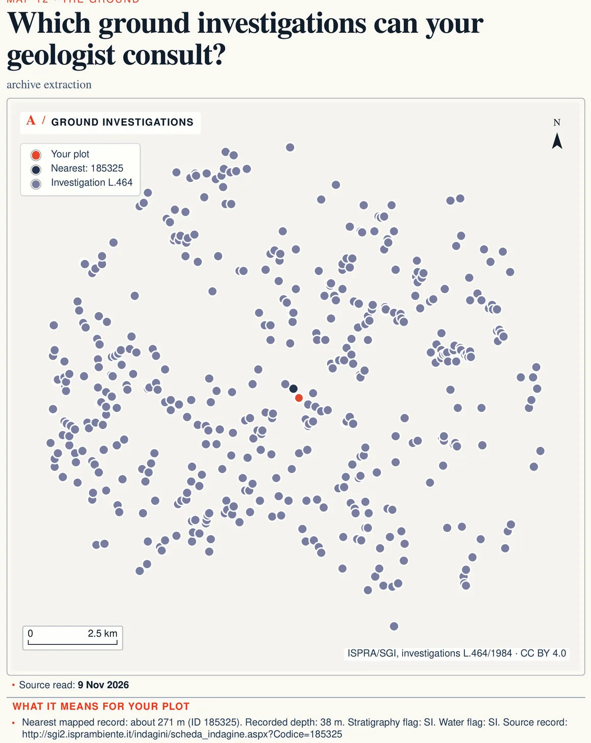
- ISPRA archive of subsurface investigations (Law 464/1984). It holds records of investigations, mostly deep ones, with depth and, where available, stratigraphy and water data.
In seismic areas the design is filed with the comune’s one-stop desk, which passes it to the region’s technical office; that office sets the minimum content, and the design comes with the documents required by the technical standards (DPR 380/2001, Article 93). If the land is also under the hydrogeological constraint, the works need a separate clearance, explained in the guide to the hydrogeological constraint.
Before you buy: what to ask, and whom
- Before the offer, on the public portals. Look the parcel up on IdroGEO, the river basin authority’s PAI maps and the region’s seismic classification, and note zones and distances.
- Before the offer, with a geologist. Ask for a first reading of public data and existing investigations nearby, and whether the house you have in mind will need extensive testing. The geologist’s estimate gives the time and cost of that reading.
- At the comune’s planning office or building desk. Ask for the certificato di destinazione urbanistica (CDU, the zoning certificate) and whether the town plan includes geological studies for that zone.
- In the preliminary contract. If building is the reason for the purchase, write down who runs the tests, by when, and what happens if the results make the project too costly.
- Before the deed. Make sure the reports paid for during negotiations are in your name, or that you have permission to use them.
Geological report in Italy: when you need one and what it costs
https://terrenocheck.it/en/guide/geological-report-when-needed-italy
Checklist
Before you sign for a plot you mean to build on
Common questions
Do I need a geological report to renovate a house?
It depends on the work. The standards require it for works that bear on the ground, including foundations, retaining structures, excavation and strengthening existing structures. Replacing finishes or wiring does not touch the ground; an extension, an extra storey or underpinning does. The designer decides, and in seismic areas the regional technical office sets what the design must contain.
Who signs a geological report in Italy?
For civil engineering works, Article 41(1)(c) DPR 328/2001 identifies the work of a qualified geologo registered in section A of the professional register. Check the territorial Ordine register and the professional’s competence for the assignment. Law 112/1963 preserves other statutory professional powers; any alternative requires a specific legal basis, not just acceptance by the council.
How much does a geological report cost for a house?
There is no set fee: professional fee scales were abolished in 2012. The cost depends on how many tests are needed, what kind, how deep, and on the laboratory analyses. Ask for a written estimate, which by law lists every cost item, including expenses and contributions.
Can I reuse a neighbour’s geological report?
For minor works in areas whose ground is well known, the design may rely on existing documented tests, with the designer fully responsible. Other people’s reports carry their own rights, though: ask whoever commissioned them before you use them.
Should I have the ground tested before buying?
If the price depends on being able to build, ask a geologist for at least a first reading of public data and existing tests nearby before making an offer. Testing on someone else’s land needs the owner’s consent: if tests are needed, write them into the preliminary contract.
Keep reading
Seismic zones in Italy: what they cost buyers
The hydrogeological constraint (vincolo idrogeologico): what it stops, who approves works, and what to check on an existing house
PAI flood and landslide risk in Italy: before you buy
Building a house on agricultural land in Italy: who may, on how many hectares, and how much
Landslides, seismic risk and nearby investigations, before you call a geologist
Pick the parcel on the map: PAI hazard areas, recorded landslides, seismic zone, microzoning and nearby subsurface investigations are read for that plot, each with a source and date, along with the questions to ask the geologist.
€29 in English or Italian · €39 in both languages · total, VAT included