
What you can build in Italy: PRG, PUC and the right to build
A planning label is not a building licence. This guide shows how national, regional and municipal rules combine, how to read the indices, and why farmland rarely means a villa.
Contents
- Start with the hierarchy, not the estate agent’s adjective
- The six homogeneous zones: useful shorthand, not a licence
- The two indices that people routinely confuse
- Density, distances, height and public standards still bite
- Agricultural land: the villa misunderstanding
- Which building title applies?
- Budget for the contribution, not just the brickwork
- Why two neighbouring plots can have different rights
What you can build depends on the parcel’s planning designation, the applicable NTA, existing development rights and every relevant constraint. The certificato di destinazione urbanistica reports the designation and prescriptions; the land’s appearance, a map colour or the description terreno edificabile does not answer the question on its own.
In Italy, the right to build is assembled from several layers. A national statute supplies the framework. Your region chooses the planning machinery and adds rules. Your comune draws the zoning line and writes the NTA, the norme tecniche di attuazione. A landscape plan, hazard rule, road setback, heritage restriction or old building right can then reduce the result to zero.
A cheap plot can therefore become a very expensive mistake. Use this buyer guide for orientation, not as a certificate of buildability or professional advice.
Start with the hierarchy, not the estate agent’s adjective
Read the plot from the top down. Each layer narrows the answer; approved landscape prescriptions can prevail over the municipal result.
- Layer 1 — National frameworkDPR 380/2001: title, conformity and contribution rules, especially Articles 10, 12, 16, 22 and 6-bis.
- Layer 2 — Regional planning lawCurrent regional law and implementation acts: planning instruments, rural buildings, procedures and standards.
- Layer 3 — Municipal planPRG, PUC, PGT or equivalent: the effective plan sheet for the exact foglio and particella.
- Layer 4 — NTA and building regulationZone article, uses, index, coverage, height, setbacks, minimum lot, implementation route and conditions.
- Layer 5 — Regional landscape planBinding prescriptions and authorisation route; approved prescriptions bind and prevail over the municipal answer.
The national statute does not replace local zoning. Article 12 of DPR 380/2001 says a building permit must conform to the planning instruments, building regulations and the current urban-building discipline. It also ties the permit to existing or planned primary urbanisation, or to the applicant’s commitment to provide it.
The regional names are not interchangeable. Campania’s L.R. 16/2004 makes the PUC the general municipal plan, read with its structural plan and building regulation. The official text is a warning against importing another region’s terminology.
In Lombardy, L.R. 12/2005 uses the PGT, as the regional government explains. Tuscany’s L.R. 65/2014 distinguishes structural and operational plans in its official text. Locate the effective municipal rule for the parcel.
The NTA are not explanatory notes. They make the right practical. Rome’s PRG document shows that amendments can carry safeguard rules before final approval. Ask which version was effective on the relevant date.
The landscape layer sits above the municipal answer. Articles 135 and 143 of D.Lgs. 42/2004 make approved prescriptions immediately binding and prevailing. For protected landscapes, Article 146 generally requires authorisation before works proceed. Read the landscape-constraint guide alongside the regional map. A PUC cannot authorise what binding landscape rules prohibit.
Pages from the delivered dossier
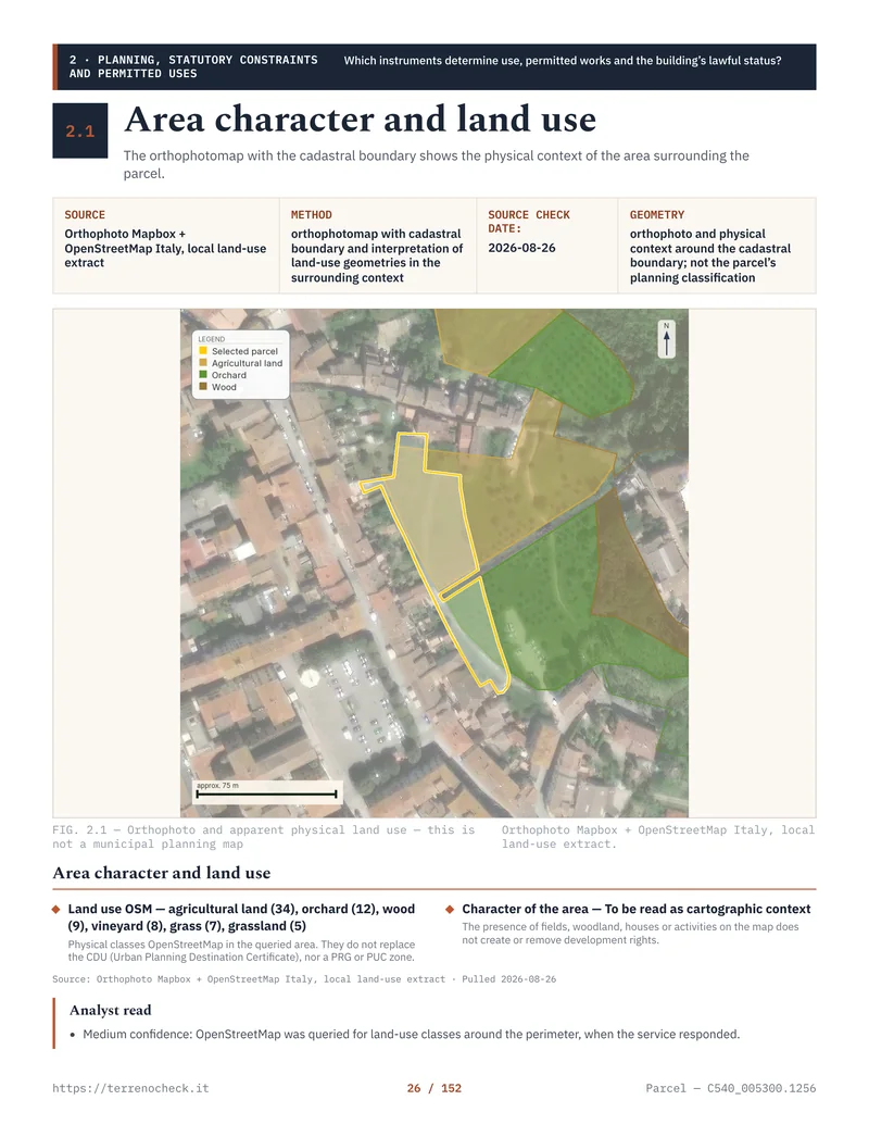 Open the full page
The six homogeneous zones: useful shorthand, not a licence
DM 1444/1968, Article 2 supplies the familiar A-to-F classification. It is a national framework for the formation and revision of urban plans. The municipality still decides how the zone is drawn, what uses are listed in the NTA and what implementation route applies.
The six homogeneous zones
| Zone | What the decree means | What it usually means in a buyer’s file |
|---|---|---|
| A | Historic, artistic or specially valuable urban areas, including integrated surrounding parts. | Conservation, restoration and tightly controlled change. A new house is exceptional and must fit the historic rules, height and existing relationships. |
| B | Fully or partly built areas outside A. Under DM 1444/1968, Article 2, letter B), partial building means at least 12.5% covered surface and territorial density above 1.5 m³/m². | Existing urban fabric, redevelopment or completion. An empty gap on the map is not necessarily a free-standing building plot. |
| C | Areas for new settlement complexes, still unbuilt or below the B thresholds. | Often development through a plan or convention, with public-space and infrastructure obligations. The NTA decides whether direct construction is possible. |
| D | Areas for new industrial or similar plant. | Productive uses, not an automatic residential villa right. Residential caretaker or service uses, if any, are tightly plan-dependent. |
| E | Areas for agricultural use, except agricultural areas whose fragmentation requires C-type settlements. | Farming and rural functions. New housing is generally tied to the regional and municipal agricultural rules, not to ownership alone. |
| F | Areas for equipment and installations of general interest. | Public or general-interest facilities. Private residential use is not the default. |
Source: DM 1444/1968, Article 2
“Agricultural” in a listing describes the planning destination. It does not mean “a villa zone with a larger garden”.
The two indices that people routinely confuse
The indice di edificabilità fondiaria, or IF, works on the superficie fondiaria, the land available for building after relevant territorial and public-service areas have been excluded. It is commonly expressed as cubic metres per square metre, m³/m².
The indice di edificabilità territoriale, or IT, works on the superficie territoriale, the whole transformation area, including land needed for roads, public services and other territorial equipment. It is often expressed as permitted gross floor area per square metre, m²/m².
Those conventions are not universal measuring rules. The Comune di Milano’s PGT NTA Article 5 is a useful local example defining ST, IT, SF and IF. Read your own NTA before putting a number into a spreadsheet.
The arithmetic looks simple:
- If the eligible SF is 1,000 m² and IF is 0.50 m³/m², the headline maximum is 500 m³.
- If the eligible ST is 5,000 m² and IT is 0.20 m²/m², the headline maximum is 1,000 m² of gross floor area.
Neither result is automatically the footprint of a house. The NTA may count existing volume, require a minimum lot, limit coverage, reserve land for roads or services, and define gross floor area differently. A 500 m³ allowance is not “a 500 m² house”.
You also need the lotto minimo, the minimum lot area or agricultural holding for the proposed use. It is municipal or regional, not national. A 2,000 m² parcel may have an index and still fail the minimum-lot, frontage, access or shape test.
Source: Comune di Milano PGT NTA Article 5 — for definitions; multiplication is a worked example, not a real-parcel right
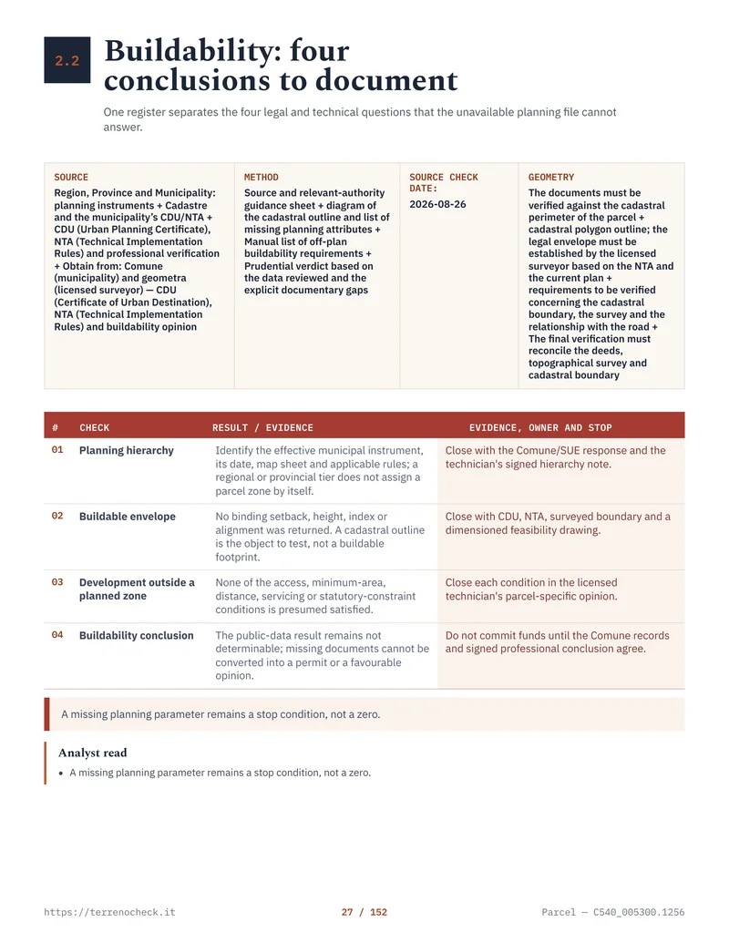 Open the full page
Density, distances, height and public standards still bite
DM 1444/1968 puts national minimum or maximum parameters around the planning exercise.
DM 1444/1968 parameters that still bite
| Parameter in DM 1444/1968 | Sourced figure | What it changes in practice |
|---|---|---|
| Residential public standards, DM 1444/1968, Article 3 | 18 m² per inhabitant, excluding roads: 4.5 m² education, 2 m² common facilities, 9 m² parks/play/sport, 2.5 m² parking. | A development can need land or a financial/conventional answer for public services. |
| Smaller C-zone settlements, DM 1444/1968, Article 4, point 3 | 12 m² per inhabitant, including 4 m² for schools, where the planned population does not exceed 10,000. | The reduced standard is a conditional rule, not a universal discount for every rural plot. |
| E-zone residential density, DM 1444/1968, Article 7, point 4 | 0.03 m³/m² maximum fondiary density for housing under the decree’s stated framework. | On 2,000 m², the arithmetic headline would be 60 m³, before regional, municipal and other restrictions. That is not a villa entitlement. |
| New buildings, DM 1444/1968, Article 9, points 2 and 3 | 10 m minimum between facing windowed walls in other zones; in C, the distance between facing windowed walls must also be at least the height of the taller building. | A theoretical volume may not fit on the lot. |
| New industrial development, DM 1444/1968, Article 5, point 1 | At least 10% of the area for public space, collective activities, public green or parking, excluding roads. | Productive development carries a land/service burden. |
| New commercial or office development, DM 1444/1968, Article 5, point 2 | 80 m² of public or collective space per 100 m² of gross floor area, at least half for parking; in A and B the amount can be halved where adequate facilities are provided. | Commercial rights are not measured like a small residential plot. |
The decree also controls height. In Zone A, new construction cannot exceed surrounding historic buildings; in Zone B, it normally cannot exceed surrounding buildings, subject to plan-based exceptions. Elsewhere, the plan relates height to distance. See Articles 5, 7, 8 and 9 of DM 1444/1968.
Article 9 of DM 1444/1968 also adds road-width margins: 5 metres per side for a road under 7 metres, 7.5 metres per side for a road from 7 to 15 metres, and 10 metres per side where it is wider than 15 metres. Check the local road classification and building regulation.
Source: Articles 3 and 4 of DM 1444/1968. The 12 m² bar applies where the planned population does not exceed 10,000; it is not a general rural discount. These are public-standard burdens, not a calculation of the area available on a particular parcel.
Agricultural land: the villa misunderstanding
The usual foreign-buyer sentence is: “We are buying 10,000 square metres, so there must be enough index for a house.” It confuses ownership, area and an agricultural business.
National law does define the agricultural operator. D.Lgs. 228/2001, Article 1 restates Civil Code Article 2135: an agricultural entrepreneur carries out cultivation, forestry, animal breeding or connected activities. D.Lgs. 99/2004, Article 1 defines the IAP, the imprenditore agricolo professionale, for national-law purposes using professional competence and the thresholds of at least 50% of total working time and 50% of global work income from agricultural activities, with a 25% threshold in disadvantaged areas. The regions certify the qualification.
That definition is not a house ticket. Regional planning law decides how an agricultural building may be authorised, what business evidence is required and what obligations attach to it.
The difference is visible in official regional material. Tuscany’s L.R. 65/2014 regulates rural interventions and agricultural company programmes. Emilia-Romagna’s L.R. 24/2017, Article 36, implemented by DGR 623/2019, uses the PRA to demonstrate the need for certain farm buildings and separately for an agricultural entrepreneur’s housing. The municipal plan remains part of the control.
An annesso agricolo is a farm-justified building for storage, livestock, processing or equipment. It is not a holiday home with a tractor parked outside. Conversion to residential use may be prohibited or treated as a new intervention under regional law and the comune’s NTA.
If you are not an IAP or coltivatore diretto, do not assume that paying an architect solves the problem. A non-professional owner may have a route for an existing building or a use specifically permitted by the local plan, but the municipality may require a company programme, agricultural registration, functional connection, minimum holding, a covenant against changing use, or proof of necessity. Those conditions vary. Anyone who gives you one national hectare rule without asking the region is guessing.
This is where the agricultural land and pre-emption guide deserves a separate read. Pre-emption and buildability are different checks. A buyer can clear one and fail the other.
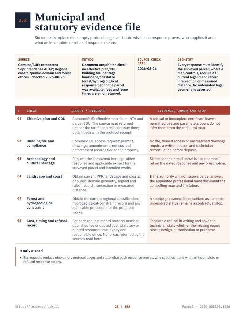 Open the full page
Which building title applies?
The title comes after planning conformity. It does not create the right to build.
- Permesso di costruire. Article 10 of DPR 380/2001 covers new construction, urban redevelopment and specified heavier transformations. A new rural house or farm building normally follows this route only if the plan permits it.
- SCIA, the segnalazione certificata di inizio attività. Articles 22 and 23 cover defined interventions in conformity with the plans and regulations, including the permit-alternative route for specified work. Regional law can add detail.
- CILA, the comunicazione di inizio lavori asseverata. Article 6-bis is the residual route for work outside the statutory lists for free activity, a permit or SCIA. The qualified technician attests the conditions; it does not create a building right.
Treat this as orientation, not a filing instruction. Building regulations, regional law, landscape authorisation, seismic filing, hydrogeological approval and other consents can change the route. A CILA does not legalise a forbidden use. A SCIA does not turn Zone E into a residential zone.
Budget for the contribution, not just the brickwork
Under Article 16 of DPR 380/2001, the release of a building permit normally brings a contribution for construction measured through two different components: oneri di urbanizzazione, the urbanisation charges, and costo di costruzione, the construction-cost component. Primary urbanisation covers items such as residential roads, parking, sewers, water, electricity and gas networks, public lighting and equipped green space. Secondary urbanisation covers the public facilities defined in the statutory framework.
No national euro-per-metre price exists. Regional tables and municipal resolutions drive it; use, zone, intervention, area or volume and exemptions matter. Ask the SUE for its current calculation sheet before calling a plot “buildable”. Add design, surveys, geologist, connections, access, landscape process and any convention.
Why two neighbouring plots can have different rights
Look at the boundary between them, not the view from the road. The zoning line may run through one parcel. One plot can be B and the next E. One can sit inside an approved implementation plan; the other can require a plan before any permit. One may have unused rights; the other may already have its volume consumed by a building that was demolished, divided or transferred.
Evidence may sit in an old permesso di costruire or concession, approved plans, a demolition file, an implementation-plan convention, or a notarised deed referring to asservimento or cessione di cubatura. The Comune’s SUE holds the building file; the notary and Conservatoria hold the relevant deeds and transcriptions. Ask the comune in writing which volume for the foglio and particella has been authorised, used, demolished, transferred or encumbered, under which act, and what remains. The unauthorised works and condono guide explains why a demolished or irregular building cannot be treated as harmless history. Only a local technician reading the building file against cadastral and land-register documents can establish whether the apparent right survives.
Other differences are less visible: superficie fondiaria, minimum lot, road setback, landscape or public-service reservation, easement, legal access, flood or hydrogeological rule, agricultural condition, or plan safeguard. Cadastral area does not settle them.
The file for a serious offer is specific:
- Obtain the parcel identifiers and cadastral map from the visura catastale and parcel check, then request the CDU.
- Download the effective plan map, NTA, building regulation and implementation plan for that foglio and particella.
- Ask a local geometra or architect to calculate SF/ST, index, consumed rights, footprint, height, setbacks, access and services.
- Use MiC’s SITAP as a screen, then check the regional plan and NTA. For flood and landslide rules, start the PAI check with the competent district or regional layer.
- Ask the municipality to confirm any agricultural connection, old plan, transferred right, NTA interpretation or legal access in writing. A missing servitù di passaggio is separate; see the access-rights guide.
A listing photograph cannot answer this. If the seller will not provide plan documents, price the land as uncertain and do not pay the price of buildable land first.
Sources
- Normattiva, DPR 380/2001, consolidated text
- Normattiva, DPR 380/2001, Article 6-bis
- Normattiva, DPR 380/2001, Article 12
- Official Gazette, Ministerial Decree 1444/1968, full text
- Normattiva, D.Lgs. 42/2004, Article 135
- Normattiva, D.Lgs. 42/2004, Article 143
- Normattiva, D.Lgs. 42/2004, Article 146
- Ministero della cultura, SITAP landscape-constraint information system
- Regione Campania, regional government law 16/2004, Article 22 and current text
- Regione Lombardia, Law 12/2005 and PGT overview
- Regione Toscana, Law 65/2014, territorial and urban planning instruments
- Regione Emilia-Romagna, DGR 623/2019 implementing LR 24/2017 rural rules
- Normattiva, D.Lgs. 99/2004, Article 1, IAP definition
- Normattiva, D.Lgs. 228/2001, Article 1 and Civil Code Article 2135
- Comune di Milano, PGT NTA Article 5, definitions and indices
- Comune di Milano, PGT NTA Article 6, territorial index
- Comune di Roma, PRG NTA update and explanation