
Visura catastale and the cadastral parcel: proving which land you are actually buying
A visura catastale can identify the parcel, expose a missing building record and show where the seller's story does not fit. It cannot prove that the seller owns the land or that you can build on it.
Contents
- What a visura catastale actually is
- Read the identifiers as one address
- What the main fields mean
- How to obtain one
- 1. Agenzia delle Entrate online
- 2. SISTER and the telematic service
- 3. An office or a Comune counter
- Per soggetto, per immobile, attuale or storica?
- The Catasto Terreni and Catasto Fabbricati are related, not duplicates
- What the map and planimetria show, and what they do not
- Discrepancies that deserve a stop
- The cadastral boundary and the ground boundary do not match
- The owner’s name or quota is wrong
- A building is visible, but no urban unit is recorded
- The record needs allineamento or aggiornamento
- The foreign-buyer traps
- The same number is not the same parcel
- “A corpo” and “a misura” change the area conversation
- The surface in the visura is not an area warranty
- The ownership check that must follow the visura
For an Italian property, request the visura catastale first to confirm the recorded identifiers, classification and intestatario catastale. Differences in the foglio, particella, building record or holder’s name identify matters that must be reconciled with the title and the property on the ground.
Then comes the part that catches foreign buyers: the visura is not a title deed. The Catasto is a fiscal and identifying register. It is not the place where you prove ownership. That check belongs in the Conservatoria, now called the Agenzia delle Entrate’s Servizi di pubblicità immobiliare, through the seller’s atto di provenienza and an ispezione ipotecaria.
Use this article to see what the cadastral papers establish and what to do when the map and ground disagree. It is not title, survey, planning or building advice.
What a visura catastale actually is
The Agenzia delle Entrate describes the visura as a document released by its provincial Territory office containing identifying and classification data for land and buildings, cadastral holders, graphic data, addresses for urban units, and update notes. The official guide calls the people shown intestatari catastali, not owners. That wording matters. (Agenzia delle Entrate, La nuova visura catastale)
Use it first to answer, “Which record is the agent talking about?” It does not answer, “Does the seller own every square metre inside that outline?”
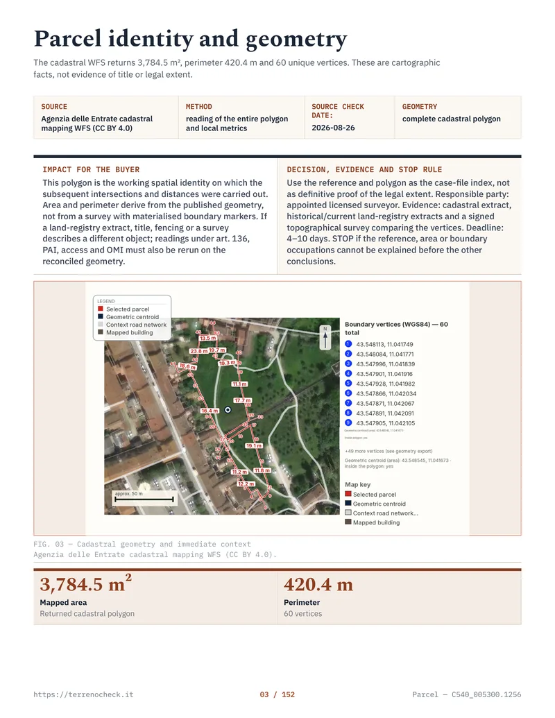
Pages from the delivered dossier
 Open the full page
Read the identifiers as one address
Do not save a listing as “the field near the church”. Save the complete identifier, exactly as it appears in the document:
- Comune catastale, the cadastral municipality. It can differ from the modern administrative municipality after boundary or municipal changes.
- Foglio, the cadastral map sheet, a cartographic portion of the municipality.
- Particella, also called mappale or numero, the parcel number within that sheet. It identifies the continuous land or building parcel recorded there.
- Subalterno, the internal identifier for a separately recorded urban unit, such as an apartment, garage or other unit in a building. A bare field in the Catasto Terreni normally has no subalterno.
- Sezione, where that cadastral municipality is divided into sections. In some areas, a denominator is also part of the parcel identifier.
The number 27 by itself tells you almost nothing. A particella 27 can occur in many comuni, and the same comune can have the number on different fogli. The official search form asks for the comune catastale, foglio and number together. (Agenzia delle Entrate, parcel search glossary)
Put the identifiers from the visura, the deed, the listing and the map into one comparison sheet. If one document says foglio 8, particella 214 and another says foglio 9, particella 214, stop. That is not a translation issue.
What the main fields mean
The terms are not interchangeable. Category is the cadastral type of a building, such as a dwelling, office, shop or special-use building. Class places the unit within the relevant category and local census area for cadastral assessment. Neither is a municipal zoning designation.
Consistenza is the cadastral measurement used for the classing of an urban unit. It is not automatically the same as the floor area a surveyor measures. For the ordinary building groups, the Agenzia describes it as rooms for group A, cubic metres for group B and square metres for group C. Groups D, E and F do not have a consistency measure in the same way. Where available, the visura may also show superficie catastale, a calculated cadastral surface. (Agenzia delle Entrate, guide to declared property values)
Rendita catastale is the cadastral income used in tax calculations. For land, you may instead see reddito dominicale, linked to the ordinary return attributed to the landowner, and reddito agrario, linked to agricultural production. These are fiscal values. They do not make land buildable or set price.
For land, the official glossary also uses hectares, are and centiare. These are genuine cadastral area units, but they still describe the register’s recorded area, not a guarantee that a fence on the ground follows the same line.
Cadastral area units
| Cadastral unit | Exact conversion | Where it appears | Source |
|---|---|---|---|
| 1 hectare | 10,000 m² | Catasto Terreni area fields | Agenzia parcel glossary |
| 1 are | 100 m² | Catasto Terreni area fields | Agenzia parcel glossary |
| 1 centiare | 1 m² | Catasto Terreni area fields | Agenzia parcel glossary |
How to obtain one
There are three practical routes.
1. Agenzia delle Entrate online
If you already hold a real right in the property, the Agenzia’s Consultazione personale online is available through the personal area with SPID, CIE or CNS. It can provide the property visura, map extract and, for an eligible holder or delegate, the planimetria. A pre-purchase buyer should not assume this free route applies. (Agenzia delle Entrate, La nuova visura catastale)
2. SISTER and the telematic service
The Agenzia’s Visura catastale telematica service is the useful pre-purchase route. Search by cadastral identifier for a current or historical visura per immobile or a map extract. A current visura per soggetto is also available. The published guide states €1.35 per property visura, €1.35 per map visura, and €1.35 per 10 cadastral units or fraction of 10 for a subject search, before payment-provider charges. Check the live checkout before relying on an old fee table.
Professionals with the appropriate convention use SISTER for cadastral and mortgage searches and for submitting updates. A buyer should not confuse that with a property-portal search. (Agenzia delle Entrate, cadastral assistance)
Published Agenzia amounts
| Request | Published Agenzia amount | What it gives you | Source and limitation |
|---|---|---|---|
| Visura per immobile, current or historical | €1.35 | Cadastral record for the identified land or urban unit | Agenzia guide; confirm the live fee |
| Visura della mappa | €1.35 | Graphic cadastral map for a Catasto Terreni parcel | Agenzia guide; payment-provider costs excluded |
| Visura per soggetto | €1.35 per 10 units or fraction | Current cadastral holdings found for the subject | Agenzia guide; not a historical title search |
3. An office or a Comune counter
You can request cadastral information at an Ufficio provinciale – Territorio of the Agenzia, or at a sportello catastale decentrato operating at a Comune, Comunità montana, Unione di Comuni or association of comuni. The counter must actually provide the service. Paper-only historical material may require the provincial office. (Agenzia delle Entrate, La nuova visura catastale)
The planimetria is different. It is a privacy-controlled document for the entitled holder or a delegated person. An agent sending you a blurry floor plan is not giving you authority to rely on it as a title document.
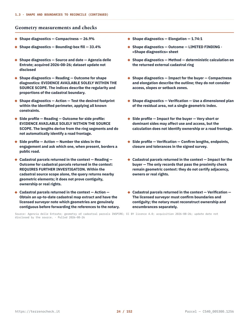 Open the full page
Per soggetto, per immobile, attuale or storica?
Visura per immobile starts with the parcel or urban-unit identifier. Use it to inspect the land in the offer, confirm its current classification and compare the record with the map. For a buyer, this is the standard first request.
Visura per soggetto starts with a person or company. Use it to see which cadastral properties are currently associated with a seller’s name or tax code when several adjoining parcels are described as one sale. It is not a substitute for an ispezione ipotecaria by name.
Visura attuale shows the current cadastral state. Request it shortly before an offer or preliminary contract, then again if the transaction drags on.
Visura storica per immobile shows recorded changes to identifiers, classing, area or cadastral holders and the update act cited by the database. Request it when a parcel was split, merged, renumbered, inherited or described differently in older deeds. The Agenzia’s guide lists historical searches per immobile and says the online subject service is current rather than historical. (Agenzia delle Entrate, La nuova visura catastale)
The Catasto Terreni and Catasto Fabbricati are related, not duplicates
The Catasto Terreni records land parcels, map identifiers, area, cultivation quality or land classification and fiscal values. The Catasto Fabbricati records urban units, including category, class, consistency, rendita, planimetry and subalterno.
A plot can therefore appear in the two systems. The Fabbricati record may point back to the corresponding Terreni parcel. A building in the urban register does not make the underlying land disappear from the map. Compare the parcel record, building record, planimetria and deed. (Agenzia delle Entrate, La nuova visura catastale)
If a rural house is described as “the land”, ask for the Fabbricati records for every building unit and the Terreni records for the parcels carrying the building, courtyard or access area. A missing subalterno may mean a different cadastral arrangement or an incomplete file. Resolve it; do not call it clean.
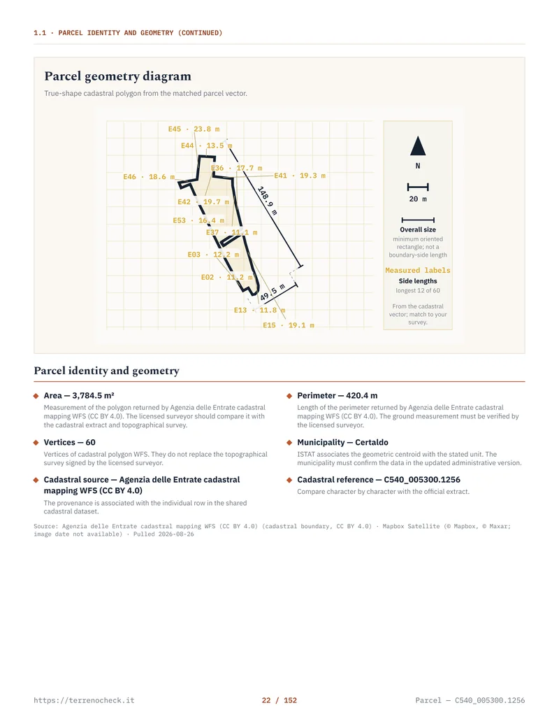 Open the full page
What the map and planimetria show, and what they do not
The estratto di mappa is the cadastral map extract for land. Compare its parcel number, outline, neighbours, roads and mapped buildings with the ground. The Agenzia’s map service can produce a selected portion of a sheet at its original map scale. (Agenzia delle Entrate, Manuale consultazione fogli di mappa)
It does not prove a fence position, establish a right of way, replace a boundary survey or decide who owns a strip occupied for decades. A cadastral line is not a magic wand for a disputed boundary.
The planimetria catastale is the floor plan of an urban unit. It can show the internal layout represented in the cadastral file. It does not approve the building, certify structural safety, prove that alterations have municipal permits or establish ownership of surrounding land.
For planning, the municipality’s current planning instrument and building file are separate. A cadastral category is not a building right. Under Article 12 of DPR 380/2001, a building permit must conform to the applicable planning instruments and building regulations. Those instruments and their detailed implementation vary by region and comune. Read the separate guide on what you can build under Italy’s PRG or PUC, and request the certificato di destinazione urbanistica when the transaction requires it.
Discrepancies that deserve a stop
The cadastral boundary and the ground boundary do not match
Distinguish three problems: a drawing or database error, an old map that does not reflect a later subdivision, and a genuine boundary dispute. A geometra compares the deed, historic maps, reference points, fences, occupation and a measured survey. The result may be a correction, cadastral update, new subdivision type, or dispute between owners.
Do not let a seller solve a boundary disagreement by repainting a gate. If the land is priced by usable area, commission the survey before you sign a binding offer.
The owner’s name or quota is wrong
An outdated name, missing inheritance, wrong tax code or unrecorded transfer may need a voltura catastale, pre-allineamento or correction. The Agenzia’s guide lists €70 in cadastral taxes and €16 in stamp duty per voltura application for the stated afflusso procedure. That is the public charge, not the professional fee. (Agenzia delle Entrate, Voltura Web guide)
If the deed is missing, the problem is not solved by making the visura look newer. Follow the title chain at the Registri Immobiliari.
A building is visible, but no urban unit is recorded
A building can be absent from the Catasto Fabbricati, appear under an old identifier, or have been recorded with a planimetria that no longer matches. The Agenzia provides a service for “fabbricati non presenti al Catasto”, which tells you this is a recognised administrative problem, not an exotic one. It does not tell you that the building has planning permission. A technician must compare the physical building with the municipal planning file, permits, any amnesty file and the cadastral record. (Agenzia cadastral assistance services)
The record needs allineamento or aggiornamento
Allineamento usually concerns making the cadastral database line up with an act or an existing record. Aggiornamento may mean a new DOCFA for an urban unit, or a PREGEO-based map or parcel update for land. The name of the practice is not a diagnosis. Ask the technician to state in writing what is wrong, which document proves the correct state, what they will file, what remains a planning or title problem, and whether the buyer or seller pays.
Professional fees are individually negotiated; no published national range gives a reliable fixed answer. Article 9 of D.L. 1/2012, converted by Law 27/2012, abolished the professional tariffs for regulated professions and requires the professional fee to be agreed with a written estimate showing costs, expenses and contributions. (Normattiva, Article 9)
Use a written estimate for the exact file: the work, expenses and contributions should be stated before you rely on a figure. For the wider budget, see the purchase-cost guide.
A boundary that needs measurement is not a paperwork exercise.
Source: Agenzia delle Entrate, Voltura Web guide; Article 9 of D.L. 1/2012, converted by Law 27/2012
The foreign-buyer traps
The same number is not the same parcel
A UK, US or German buyer may expect a property number to behave like a unique address. It does not. Write the comune catastale, foglio, particella and, for a building, subalterno. “Parcel 42” is an invitation to confusion.
“A corpo” and “a misura” change the area conversation
Italian Civil Code Articles 1537 and 1538 distinguish a sale a misura, priced by a unit of measurement, from a sale a corpo, priced for the property as a whole even if an area is written in the contract. In a misura sale, Article 1537 gives the buyer a reduction where the effective measure is lower than the contractual one. In a corpo sale, Article 1538 generally allows no price reduction or supplement unless the real measure is lower or higher by one twentieth, or 5%, than the measure stated in the contract. These are national Civil Code rules, not a regional cadastral convention. (Normattiva, Civil Code)
Contract wording and area rule
| Contract wording | Numerical rule | Practical consequence | Source |
|---|---|---|---|
| A misura | Price is tied to each unit of measure | A lower effective measure can support a proportional reduction under Article 1537 | Civil Code Article 1537 |
| A corpo | One twentieth = 5% | No ordinary adjustment below that threshold under Article 1538; an excess can create a choice between supplement and withdrawal | Civil Code Article 1538 |
- A MISURAIs there a shortfall in the measured area? → YES — SHORTFALL → A shortfall supports a proportional reduction under art. 1537 c.c.
- A CORPO — NO — WITHIN 5%Does the real measure differ from the contractual one by more than one twentieth (5%)? No ordinary adjustment under art. 1538 c.c.
- A CORPO — YES — REAL MEASURE LOWER BY MORE THAN 5%Apply the art. 1538 c.c. remedy for the shortfall
- A CORPO — YES — EXCESS BY MORE THAN 5%Buyer chooses between paying a supplement and withdrawing
The article number does not turn a bad description into a good one. Put the identifiers, deed description, surface and contractual formula in front of the notary before the preliminary contract. If price depends on usable or buildable area, ask what was measured and how.
The surface in the visura is not an area warranty
The cadastral surface is a recorded or calculated fiscal datum. The map is cadastral cartography. Neither promises that the land is exactly that size on the ground, that every part is accessible, or that every square metre has the planning status the buyer expects.
Foreign buyers lose money here. They convert hectares into a price per square metre, assume the fence is the boundary, and discover after signing that a road, slope, occupation, easement or planning exclusion removes the valuable part. The visura did not lie. It was never the warranty they thought it was.
The ownership check that must follow the visura
Ask for the full atto di provenienza: the sale, inheritance, donation, division or other deed by which the seller acquired the property. Check every parcel and quota. Then obtain, or have the notary obtain, the ispezione ipotecaria for the property and prior owners. It searches transcriptions, inscriptions and annotations in the public mortgage registers, including transfers, mortgages, seizures and cancellations where recorded.
The Agenzia says an ispezione ipotecaria can identify the owner and show mortgages or legal burdens. The Notariato explains why the deed is deposited in the Conservatoria: public registration lets third parties know who the owner is and whether the property carries mortgages or other restrictions. The subsequent cadastral voltura updates the Catasto; it does not replace that public title record. (Agenzia purchase guide, Consiglio Nazionale del Notariato)
The order is simple:
- 1 — IDENTIFIERSWho: buyer or agent; exact comune catastale, foglio, particella and subalterno; cost: not separately stated
- 2 — CURRENT CADASTRAL CHECKWho: buyer or delegated professional; current visura per immobile €1.35 and estratto di mappa €1.35; source: Agenzia delle Entrate, La nuova visura catastale
- 3 — HISTORICAL CADASTRAL CHECKWho: buyer or delegated professional; historical visura per immobile €1.35 in the published guide, confirm the live fee; source: Agenzia guide
- 4 — DOCUMENT MATCHWho: buyer, seller and notary; compare cadastral records with the atto di provenienza and the seller’s claimed share; cost: not stated
- 5 — TITLE INVESTIGATIONWho: notary or buyer’s title professional; check ownership, mortgages and registered burdens through the Conservatoria / Registri Immobiliari and an ispezione ipotecaria; cost: not stated in the sources used here
- 6 — SPECIALIST RESOLUTIONWho: geometra for a boundary or building mismatch, notary for title and contract consequences; professional fee: not stated because fees are individually negotiated
Source: Agenzia delle Entrate and Consiglio Nazionale del Notariato; published charges and professional-fee context
Sources
- Agenzia delle Entrate, La nuova visura catastale
- Agenzia delle Entrate, cadastral and mortgage assistance services
- Agenzia delle Entrate, cadastral parcel search and glossary
- Agenzia delle Entrate, buying a home and mortgage inspection
- Agenzia delle Entrate, Manuale consultazione fogli di mappa catastale
- Agenzia delle Entrate, guide to declared property values
- Agenzia delle Entrate, Voltura Web guide
- Consiglio Nazionale del Notariato, activities after signing
- Normattiva, Civil Code, Articles 1537 and 1538
- Normattiva, D.L. 1/2012 converted by Law 27/2012, Article 9
- Normattiva, DPR 380/2001, Article 12