
How to find the foglio and particella of Italian land
The foglio and particella of a plot can be read on the Agenzia delle Entrate cadastral geoportal, even when the listing leaves them out. Trento and Bolzano keep their own cadastre.
50 m
Example parcel · Diano San Pietro (Imperia)
D298A000700.444 · 1,247 m²
Neighbouring parcels
Source: Cadastral geometry: Agenzia delle Entrate, CC BY 4.0 · read 18 October 2026
Contents
In short
- Italian land is identified by cadastral comune, section where used, foglio and particella: the parcel number alone is not enough.
- The Agenzia delle Entrate geoportal is free to use and shows land-register parcels, without holders or income figures.
- If the listing gives no numbers, you can reach the parcel by navigating the map from the photos, then order the visura.
- Trento and Bolzano are not on the geoportal: their cadastre and land book are run by the provinces.
4 items
To identify land
Cadastral comune, section if any, foglio, particella.
Trento and Bolzano
Not on the geoportal
Cadastre run by the autonomous provinces.
Already have a parcel in mind? The report checks it against public data, with a source and date for every finding. Open the map → €29 in English or Italian · €39 in both languages
Comune, section, foglio and particella
Italian land is not identified by a street address. The cadastre uses an identifier made of several parts, and each one matters.
The cadastral comune is the area where the property is registered. It may differ from the administrative municipality: after mergers or boundary changes an older name sometimes remains, and the visura shows the cadastral one.
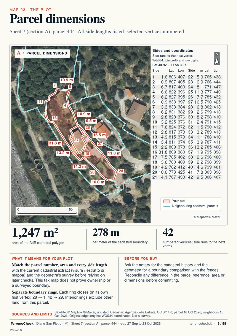
The section appears only in some municipalities, sometimes as a letter. Where it exists, it is part of the identifier: the sample report’s parcel is number 444 of foglio 7, section A, in Diano San Pietro.
The foglio is a sheet of the municipal map. Parcel 12 on foglio 3 and parcel 12 on foglio 18 are two different pieces of land.
The particella, also called mappale, is the piece of land, or the building with its plot, on that sheet. Without the comune and the foglio, the number on its own identifies nothing.
The subalterno belongs to the building register: it marks an urban unit on a parcel, such as a flat or a garage. A bare field without buildings has none.
A page from a delivered report
The cadastral geoportal, step by step
The official starting point is the Agenzia delle Entrate Geoportale Cartografico Catastale. It is free to use and needs no SPID.
The Agenzia states three limits. The service covers Italy except the areas where the cadastre is run by the autonomous provinces of Trento and Bolzano. It shows the land-register map, not full property records. The data belong to the Agenzia and are released under a CC BY 4.0 licence, so anyone reusing them must credit the source.
- Open the geoportal and choose region, province and comune.
- If you have the numbers, enter the foglio and particella and run the search.
- If you do not, move and zoom the map until roads, buildings and parcel outlines appear.
- Switch on the parcel information tool and click the plot: the comune, section if any, foglio and parcel number are shown.
- Write down the full identifier and compare it with the seller’s deed, the visura and the listing.
Free map viewing does not give holders, income figures, land quality or the parcel’s history. For those the Agenzia points to the visura; since January 2025 online visure are free even for property you do not own, as the guide to the free online visura explains.
A listing without foglio and particella
Many listings show an aerial photo, a fence and a price, but no cadastral numbers. You can still start from the map.
Recognise the land from the photos: a road, a river, a roof, the shape of the field. On the geoportal choose the comune and zoom in until the parcel outlines are readable, then query the parcel.
Count the parcels. A one-hectare olive grove for sale can be made up of several mappali. Note every identifier inside the fenced area in the photos. If the agent talks about one parcel and the fence covers three on the map, ask for the full list before going further.
With comune, foglio and particella you can order the visura and compare area, land quality and cadastral holder with what you were told. The cadastral holder is not proof of ownership: ownership is checked in the property registers, with the deed and a mortgage-register search, and the notary’s part is set out in the guide to the notary’s checks.
Trento and Bolzano: a provincial cadastre
The Agenzia delle Entrate geoportal does not cover the autonomous provinces of Trento and Bolzano, where the cadastre and the land book are run by the provinces. TerrenoCheck works on the national cadastral map and does not cover those areas for now either.
In Trento the provincial land book and cadastre service issues visure and map copies at its offices. A non-certified copy of the census data for one parcel costs €3.00. The OPENkat portal offers online visure but requires a contract with the province: the yearly fee for a single-user contract is €90.00, plus the charge for each search.
In Bolzano the land cadastre and the land book are provincial, with their own rules and numbering. Ask the provincial cadastre offices for the identifiers.
Both provinces use the land-book system: the cadastral identifier and the land-book entry do not replace each other. Before paying a deposit, have a local notary read both.
What the cadastral map does not tell you
The map identifies the parcel. It does not say who owns it, it does not fix the legal boundary, it does not say whether you can build and it does not list mortgages.
The cadastre serves tax and mapping purposes. In boundary disputes a judge relies on cadastral maps only when other evidence is missing (Article 950, third paragraph, of the Civil Code). The fence, possession and the deed may say something else, as the guide to cadastral and real boundaries explains.
Planning rules sit in the municipal plan and in the planning certificate (CDU). Land described as buildable in a listing does not become buildable because the parcel appears on the map.
If the map and the deed do not match, stop before the deposit and ask the seller and the surveyor for a written explanation.
How to find the foglio and particella of Italian land
https://terrenocheck.it/en/guide/foglio-particella-geoportale-italy
Checklist
Before making an offer
Sources (8)
Sources checked 22 October 2026.
- Agenzia delle Entrate, Geoportale Cartografico Catastale · checked
- Agenzia delle Entrate, cadastral geoportal page · checked
- Agenzia delle Entrate, cadastral map consultation · checked
- Agenzia delle Entrate, online visura service guide · checked
- Autonomous Province of Trento, cadastral records and copies · checked
- Autonomous Province of Trento, OPENkat · checked
- Autonomous Province of Bolzano, land cadastre · checked
- Normattiva, Civil Code, Article 950 · checked