
Legga questo articolo in italiano.
Buying land affected by wildfire in Italy
On this page
Article 10 of Law 353/2000 protects the previous designation of burnt woodland and pasture for at least 15 years, subject to its exceptions. Ten-year prohibitions have different scopes. Ask the municipality for the event date and approved boundary before having your intended use assessed.
In short
- Burnt woodland and pasture: at least 15 years preserving the previous designation, subject to Article 10’s exceptions explained below.
- Ten-year prohibitions differ by activity and land category. The building exception requires examination of pre-fire planning instruments.
- Request the approved event boundary and date from the Comune (municipality). EFFIS satellite mapping does not replace the municipal register.
- Sales in the specified zones within 15 years require express reference to the restriction, on pain of nullity. Give the records to the notary.
Article 10
Different scopes
Land use, building, grazing and collection have distinct rules.
Law 353/2000
Comune
Municipal fire register
Obtain the approved boundary and event date.
Law 353/2000, Article 10(2)
The report brings together public information about the land, with sources and dates, to prepare questions for the relevant offices: €29 in English or Italian · €39 in both languages · total, VAT included.
Establish what burnt and which part of the property it covered
Article 10 of Law 353/2000 distinguishes restrictions by land type and activity. The rule on retaining the previous use concerns burnt woodland and pasture; other rules refer specifically to woodland. “Burnt land” should therefore not be treated as one legal category covering every field and every proposed use.
Ask the Comune, the municipality, for its catasto incendi, the register of land affected by fire, and the approved boundaries. You need the event date, the affected area and the relevant decisions. If the fire predates a subdivision, have the technician connect today’s parcel identifiers to those used when the fire occurred.
Vegetation may have regrown by the viewing. The current appearance does not replace the documentary check, and a treeless photograph does not prove that woodland was absent before the fire. The separate private woodland guide deals with woodland classification and management requirements.
The fifteen-year land-use restriction has a defined scope
Woodland and pasture whose vegetation has been affected by fire must retain their previous designation for at least fifteen years. The legislation nevertheless permits public works necessary to protect public safety and the environment. That provision does not authorise a private house merely because the owner describes it as restoration of damaged land.
Paragraph 1-bis provides a specific exception to the first sentence for an owner who is the victim of extortion, including an attempt, established by a final judgment. It requires the statutory connection between the threat or violence and the specified fire offences, and reporting the extortion demand to the judicial authorities or judicial police. A lawyer needs the judgment and facts before applying it; it is not a general exception for owners who did not start the fire.
Ask how the restriction applies to the part being purchased and its pre-fire designation. Even after the applicable period ends, the local plan and other protections still need examination. The end of a temporary restriction is not itself permission to change use or construct a building.
- Change designationWoodland/pasture: at least 15 years; read permitted public works and the specific paragraph 1-bis exception
- BuildTen years in the statutory cases, with exception for works provided for by pre-fire plans; separate rule for municipalities without a plan
- Grazing, hunting, collectionBurnt woodland scope and distinct Article 10 periods
Sources: Law 353/2000, Article 10: restrictions, exceptions and fire register; JRC, EFFIS: burnt-area method and limitations; accessed 13 November 2026.
The ten-year restrictions cover different activities
For ten years, the specified burnt areas are subject to a prohibition on buildings and structures or infrastructure intended for residential settlements and productive activities. The legislation preserves cases where the works were provided for by planning instruments in force before the fire. That exception requires examination of those instruments, rather than a general statement that the zone was once described as buildable.
There is also a specific rule for municipalities without a planning scheme: all building on burnt woodland is prohibited for ten years. Grazing and hunting are separately prohibited for ten years on burnt woodland vegetation areas. A burnt pasture and burnt woodland must not be treated as interchangeable when reading these particular prohibitions.
Collection of woodland undergrowth products is prohibited for three years on burnt woodland areas. Describe the intended activity when requesting advice. A fence, a new house, timber work and agricultural use raise different questions; a general request asking whether the land can be “used” may not address the proposal that matters to you.
Bring an activity-specific table to the adviser
| Article 10 rule | Scope and period | Evidence to check |
|---|---|---|
| Previous land-use designation | Burnt woodland and pasture: at least 15 years | Prior use; permitted public works; any paragraph 1-bis case |
| Buildings and infrastructure for settlements or production | Specified burnt areas: 10 years | Exception for works provided for in pre-fire planning instruments |
| All building where the municipality has no planning scheme | Burnt woodland: 10 years | Planning-scheme position and land classification |
| Grazing and hunting | Burnt woodland vegetation areas: 10 years | Boundary and date; do not automatically extend to pasture |
| Undergrowth products | Burnt woodland: 3 years | Activity and affected portion |
Article 10 also restricts publicly financed reforestation and environmental engineering for five years, with specific authorisation routes for the situations described in the legislation. If you intend to seek funding, take the proposed work and funding source to the competent body. This is not a general prohibition on every form of land care.
Municipal records and satellite mapping serve different purposes
The municipality must update its Article 10 register annually. The list is published for thirty days for observations; the law then provides for examination of those observations and approval of final lists and boundaries within the following sixty days. Check whether the document supplied is a list still under consultation or the final approved record.
EFFIS, the European Forest Fire Information System, maps burnt areas from satellite imagery. Its technical documentation explains that the boundaries are produced at particular resolutions and do not acquire the precision of the aerial-image background on which they are displayed. Do not treat the edge of a satellite burn polygon as the legal boundary of a restricted part of a parcel.
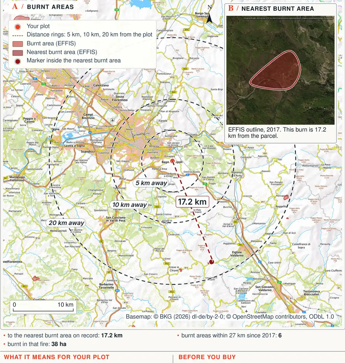
In the Bagno a Ripoli sample, the nearest recorded burn is from 2017 and lies 17.2 km away. The sample expressly says that this distance provides no information about fire on the parcel and that small fires can be missing from the inventory. The practical check remains a parcel-specific question to the municipality, even where the satellite map shows no nearby burn.
EFFIS also cautions that its start and last-update dates may not match the actual ignition and extinction dates. If your legal assessment depends on when the fire occurred, ask the municipality for the event record. Keep that date separate from the date on which a satellite boundary was last updated.
From satellite context to the deed file
- EFFISContext and data limits
- MunicipalityEvent date and approved boundary
- Technician and lawyerActivities, categories and any exceptions
- NotaryStatutory deed reference where required
Sources: Law 353/2000, Article 10: restrictions, exceptions and fire register; JRC, EFFIS: burnt-area method and limitations; accessed 13 November 2026.
Tell the notary before the deed is drafted
For sales of land and property in the specified zones within fifteen years of the fire, Article 10 requires express reference to the land-use restriction, on pain of nullity. Send the boundaries and dates to the notary before the deed is prepared. An estate-agent description or an oral statement during a viewing is not the deed wording required by the law.
If the seller supplies an older statement, ask which period and parcels it covers. Later fires must also be investigated. The technician can prepare an understandable comparison of the current parcel and affected area while keeping the municipal record distinct from satellite observations.
For land marketed as a future house plot, obtain the local planning assessment as well. The fire check does not replace the CDU, the certificate of planning designation, the plan rules or other constraints. Where excavation is proposed, the hydrogeological-constraint guide explains a further separate inquiry.
If your purchase depends on a particular use, have the adviser put that use into the written assessment. A conclusion about grazing does not establish that a new structure is permitted. Keep the intended activity consistent between the enquiry, technical opinion and any contractual condition.
Sequence the enquiries before making an offer
- Municipality, before the offer: request the approved list, boundary, updates and event date. Ask for the submission route, document charges and expected response time.
- Technician, before valuing future use: compare the present cadastre, burn boundary and, where relevant, pre-fire planning instruments. Agree the delivery date and fee in writing.
- Responsible authority, before works: describe the actual proposal and obtain the applicable approval route and procedural timing.
- Notary, before the contract: supply the complete file for the statutory deed reference and treatment of unresolved checks in the preliminary agreement.
A hypothetical area calculation shows why the boundary matters. If 1,500 m² of a 6,000 m² purchase lies within the affected area, that is 25% of the surface. This does not justify extending the restriction to the remainder or ignoring the affected portion. Ask for a drawing that makes both parts identifiable.
Use actual quotations for the budget. Assumed technical review costs of €500 and document costs of €30 give a partial €530 total. These are illustrative inputs, not official tariffs or market estimates. Replace them with the professional’s offer and the office’s charges. Payment for investigation establishes the land’s position; it does not purchase an exemption from the restrictions.
Buying land affected by wildfire in Italy
https://terrenocheck.it/en/guide/land-burnt-by-wildfire-restrictions-italy
Checklist
Before buying affected land
Common questions
Does every burnt field have the same restrictions?
No. The legislation distinguishes woodland, pasture and particular activities; classify the area and proposal.
Does an empty EFFIS map establish no restriction?
No. Small events may be missing and satellite boundaries do not replace municipal records.
Can I build once fifteen years pass?
Expiry of a temporary restriction does not itself authorise development. Planning and other protection still need assessment.
Should the notary see the fire file?
Yes. Sales within the statutory scope and fifteen-year period require an express deed reference to the restriction.
Keep reading
Buying woodland in Italy: what the forest rules let you do, and what to check before you sign
Can you build on land in Italy? PRG, PUC and zoning
The hydrogeological constraint (vincolo idrogeologico): what it stops, who approves works, and what to check on an existing house
Prepare the questions for your parcel
Select the land on the map to review its territorial information, sources and questions to take to the relevant offices before buying.
€29 in English or Italian · €39 in both languages · total, VAT included