
Woodland in Italy: what you may legally do
A wooded Italian parcel can be privately owned and still be heavily regulated. This guide explains what bosco means, which checks come before a chainsaw or an excavator, and why a forest is rarely a shortcut to a house.
Contents
- Start with the legal forest question
- The rule that surprises buyers: the landscape constraint follows the bosco
- Vincolo idrogeologico: stop before the excavator
- Cutting trees: ordinary management still has a procedure
- Reforestation can keep controlling the land
- Fire: check the Comune’s catasto incendi
- Usi civici can sit on woodland
- What can you realistically use woodland for?
The listing says bosco. That word can describe a productive private forest, an overgrown former field, a protected landscape, a parcel with collective rights, or several of those at once. It does not tell you whether you can build a cabin, clear an entrance or sell the timber next winter.
This pre-purchase guide does not provide legal, forestry, surveying, engineering, planning or tax advice. Before a non-refundable deposit, have the notary check title and a qualified local technician or forest professional test the parcel, the planned use and the applicable regional procedure.
Start with the legal forest question
For matters within the State’s exclusive competence, Article 3(3) of Legislative Decree 3 April 2018, no. 34, the Testo unico in materia di foreste e filiere forestali (TUFF), defines bosco, foresta and selva as equivalent terms. The core test is physical and legal, not the estate agent’s label. The land must carry arboreal forest vegetation, with or without shrubs, of natural or artificial origin and at any stage of development, with an area of at least 2,000 square metres, an average width of at least 20 metres, and forest tree cover greater than 20 per cent.
Those are national thresholds for the State’s fields of competence. Article 3(4) lets each region adopt an integrating definition in light of its territory, ecology and socio-economic conditions. The region can also integrate the categories of areas assimilated to forest under Article 4 and areas excluded under Article 5, but it may not lower the level of protection supplied by the national framework.
The practical implication is uncomfortable for a buyer. A green shape in an online map is useful evidence, not the legal answer. A cadastral crop description is not a forest determination. An open patch inside a wider wood can still be treated as forest, while an ornamental garden or an agricultural tree plantation may fall outside the definition. Read the regional forest law, the regional landscape plan and the parcel evidence together.
Article 4 also catches land that does not look like a conventional stand of trees. It includes land burdened by a reforestation obligation, new woods created as compensation, forest areas temporarily without tree or shrub cover because of interventions, damage or fire, and clearings under 2,000 square metres that interrupt a forest but are not permanent meadows or pastures. A photograph taken after a fire is not a clearance certificate.
The 2,000 m², 20 m and over-20% figures are the national starting point. Regional law and the statutory assimilated categories can still change the result for the parcel in front of you.
| Question | National rule | Buyer consequence |
|---|---|---|
| Core definition | Natural or artificial forest tree vegetation, with or without shrubs; area at least 2,000 m², average width at least 20 m, forest tree cover greater than 20% | Test area, canopy and continuity; do not rely on the cadastral crop code |
| Regional integration | Region may integrate the definition under Article 3(4), and may define additional assimilated or excluded areas under Articles 4 and 5 without reducing protection | Obtain the applicable regional forest rules and landscape-plan treatment |
| Assimilated forest | Article 4 includes reforestation-obligation land, compensatory new woods, temporarily unstocked forest and qualifying clearings under 2,000 m² | Bare ground can still carry forest restrictions |
Pages from the delivered dossier
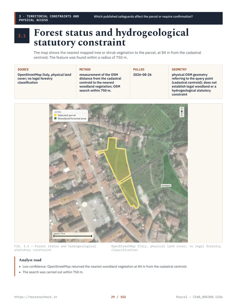 Open the full page
The rule that surprises buyers: the landscape constraint follows the bosco
Article 142(1)(g) of Legislative Decree 22 January 2004, no. 42, the Codice dei beni culturali e del paesaggio, lists territories covered by forests and woods, including areas damaged or crossed by fire, and land subject to a reforestation constraint, among the protected landscape assets. The protection operates by law when the land falls within the statutory category. It does not depend on a forest polygon being drawn in a portal.
That is the answer to the question foreign buyers often ask after seeing a blank map: “If no layer marks the parcel, is it free?” Not necessarily. A map can help establish the facts and can expose a boundary problem. It does not create the landscape constraint, and a missing layer cannot cancel Article 142(1)(g). The legal scope and statutory exceptions still need a competent reading, especially where a regional landscape plan, an urban boundary or a disputed forest edge is involved.
The landscape constraint is not the same thing as a forest-management authorisation. Article 146 is the general landscape-authorisation route for interventions that alter protected land. Article 149(1)(c) excludes a taglio colturale, forestation, reforestation and certain conservation or fire-prevention works from that landscape authorisation when they are carried out in woods listed by the Code and are provided for and authorised under forestry rules. That last condition matters. “It is only a normal cut” is not a permit.
The landscape constraint guide explains the separate authorisation system. Treat this forest article as the point where you join that check to the regional forestry file.
Vincolo idrogeologico: stop before the excavator
The vincolo idrogeologico comes from Royal Decree-Law 30 December 1923, no. 3267. Article 1 covers land of any nature or destination where uses contrary to the rules in Articles 7, 8 and 9 could cause public damage through denudation, loss of stability or disturbance of the water regime.
This is a different constraint from the landscape protection attached to a bosco, and different again from a PAI flood or landslide classification. A parcel can have one, two or all three. The region generally supplies the maps, delegated authority, application forms and technical requirements. In some territories the competent body is a regional forest office; in others, functions are delegated to a Comune, union of municipalities or another local authority.
For a buyer, the trigger is the proposed work. A new track, cut-and-fill platform, drainage ditch, retaining work, foundation excavation, stump removal or change in surface water flow may require a hydrogeological authorisation or notification, depending on the regional rules and the site. Do not ask only whether the land is “at risk”. Ask the authority whether the exact works need a nulla osta, autorizzazione, denuncia or a technical report before soil is moved.
The flood and landslide guide covers PAI and PGRA. It does not replace the hydrogeological check. A reassuring flood answer is not permission to cut a slope.
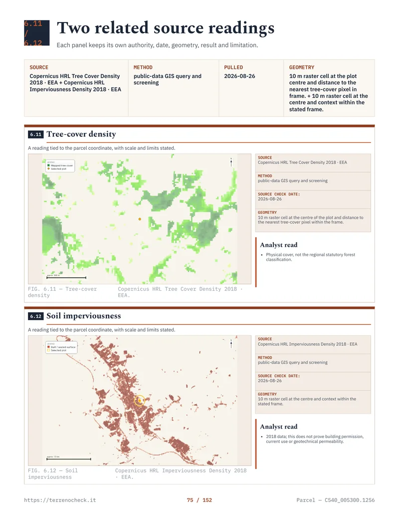 Open the full page
Cutting trees: ordinary management still has a procedure
The forestry term you will hear is taglio colturale. In practical terms, it is an ordinary silvicultural cut carried out in a way that maintains renewal, vitality and the continuation of the woodland. It can include thinning, cleaning, sanitary work, conversion or restoration work, depending on the regional rules. The purpose is management of the forest, not conversion of forest land into a garden, building platform or parking area.
Italy does not have one national form that tells every woodland owner to tick “communication” or “authorisation”. The region sets the operational route through its forest law, regulations and the local office structure. The applicable prescrizioni di massima e di polizia forestale, or the regional forest regulation that replaced or incorporates them, can govern species, season, regeneration, felling method, extraction routes, protection of watercourses and what must remain standing.
Consider the variation. Regione Piemonte says that forest cutting follows its regional forest regulation and provides two main procedures: a simple communication and an authorisation supported by a project from a forest technician. Its published page also says that, outside special situations such as Natura 2000 sites and protected areas, cuts up to 150 quintals in a calendar year for the owner’s or buyer’s self-consumption do not require a communication or authorisation. That is a Piemonte rule, not a national allowance.
Regione Toscana runs its own forest procedure under L.R. 39/2000, as amended by L.R. 49/2025 of 20 August 2025, in force from 12 September 2025. The 2025 reform places hydrogeological-constraint authorisations with the Comune or, as applicable, the Città Metropolitana di Firenze. For a buyer, identifying that competent local counter is more useful than relying on an old day count: confirm the current filing for the exact cut, whether it is a declaration, authorisation or another regional procedure.
The distinction matters even for a small private wood. A cut can be ordinary management for landscape purposes and still need a regional filing. A cut can also sit in Natura 2000, a protected area, a hydrogeological zone or a fire-sensitive period where another consent or condition applies. Keep the written filing, map, technical description, response and any imposed prescriptions with the property records.
The national landscape rule and regional forest procedure sit beside each other. A valid filing is part of the work, not evidence that every other constraint has disappeared.
| Rule or example | Published procedure or number | What a buyer should not assume |
|---|---|---|
| Landscape Code, Article 149(1)(c) | No Article 146 landscape authorisation for a qualifying taglio colturale and related forest works, provided they are authorised under forestry law | Landscape exemption does not erase a regional forest filing |
| Piemonte self-consumption | Up to 150 quintals per calendar year can be exempt from communication or authorisation outside special situations | This is regional and conditional, not an Italy-wide free-cut allowance |
| Piemonte larger or different intervention | Communication simple or authorisation with a project by a forest technician; the regional page states silence-assent after 30 days for the authorisation route | Check the exact intervention and current regulation |
| Toscana | L.R. 39/2000 as amended by L.R. 49/2025 (20 August 2025, in force 12 September 2025); hydrogeological-constraint authorisation is handled by the Comune or Città Metropolitana di Firenze | Identify the competent local counter and verify the current filing for the exact cut; do not rely on an old day count |
Source: D.Lgs. 42/2004, Article 149(1)(c); Regione Piemonte, Tagli boschivi; Regione Toscana, La nuova legge regionale sui boschi e gli ecosistemi forestali (2025).
Reforestation can keep controlling the land
The TUFF treats some reforestation situations as forest land even when the buyer sees grass, scrub or a recently cleared surface. Article 4 includes land burdened by a reforestation obligation and new woods created to satisfy compensatory duties. Article 8 regulates transformation of woodland to another use and the compensatory interventions that can follow. Regions decide the permitted cases, the technical conditions and whether compensation is carried out through new woodland, improvement work or a payment where the law allows it.
The phrase “compensatory reforestation” is not a cheap planting obligation that can be priced from an advert. Regione Piemonte publishes a separate procedure for transformation to another land use and lists D.Lgs. 34/2018 Article 8 alongside regional rules and criteria. The application can involve landscape, hydrogeological and forest authorities, plus a forest technician’s work. A seller who says “we can clear it and plant somewhere else” is describing a project that needs evidence, not offering you a right.
There is a second route by which buyers get caught. Article 3(2)(g) defines abandoned land, subject to regional rules, including agricultural land where agricultural activity has not been exercised for at least three years, subject to the stated exclusions. That three-year figure does not mean every neglected field automatically becomes a bosco on the fourth birthday. Natural regeneration must be assessed against the applicable forest definition, regional treatment and any land-use designation. But a field that has naturally reforested can move from “old agricultural land” into a forest-law and landscape-law problem, even if the cadastral record still carries an agricultural description.
Ask for dated aerial evidence, the current cadastral map, the regional forest position and the land-use history. If a reforestation obligation or compensatory intervention appears in a deed, permit, regional file or landscape-plan record, preserve the document. The buyer who clears first and asks later may face restoration, compensation and enforcement costs. No national desk review can tell you the cost of a particular restoration order without the region, area, species and works.
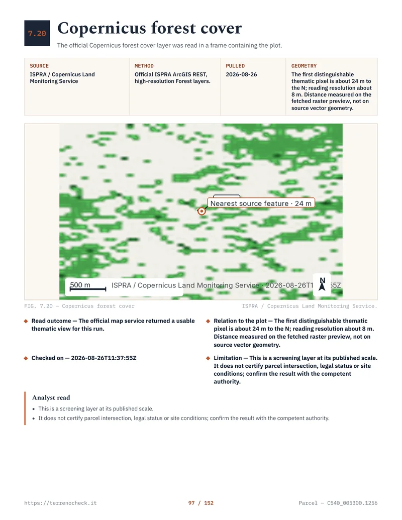 Open the full page
Fire: check the Comune’s catasto incendi
Law 21 November 2000, no. 353, Article 10 is one of the most practical checks in a woodland purchase. It does not merely describe fire risk. It imposes post-fire restrictions on wooded zones and pastures whose stands have been burned.
For at least 15 years, under Article 10(1), the land cannot have a destination different from the one it had before the fire, subject to the public-works exception stated in the law. A deed for land or buildings in the affected zone made within those 15 years must expressly mention the restriction, or the act is void. For 10 years, new buildings and structures or infrastructure for civil or productive settlements are prohibited on the burned stands, subject to the statutory exception for an authorisation or concession already issued before the fire under the then-current planning instruments. Publicly funded reforestation and environmental-engineering works are prohibited for five years, unless the competent minister or region authorises them for the documented situations listed by the law. On burned wooded stands, grazing and hunting are prohibited for 10 years.
The Comune must census the burned stands through a dedicated catasto dei soprassuoli percorsi dal fuoco, commonly called the catasto incendi. Article 10(2) provides for the initial census within 90 days of approval of the regional plan, annual updating, publication for observations and definitive perimeters. The operational files are held at Comune level, even when the fire data came from regional or national sources.
Ask the Comune for the catasto incendi entry, the fire date, the cadastral parcels and the approved perimeter. Ask for the annual update and any act that removed a restriction after the statutory period. Do not accept a screenshot of a national fire-risk map as the answer. The question is whether this exact parcel appears in the Comune’s legal fire register and which clock is still running.
- Fire dateRecord the event and exact cadastral perimeter
- 5 yearsPublicly funded reforestation and environmental-engineering works are prohibited, subject to the statutory authorisation exceptions
- 10 yearsNew civil or productive buildings, structures and infrastructure are prohibited on burned stands; grazing and hunting are also prohibited on burned wooded stands
- 15 yearsA different land destination is prohibited and a sale deed must expressly mention the restriction
Source: Law 353/2000, Article 10, consolidated text published by Regione Puglia.
Usi civici can sit on woodland
Woodland can be private in the cadastral record and still carry an uso civico, such as collective rights to graze, collect firewood or use forest products. It can also be part of collective-domain property rather than ordinary private land. That changes who can manage the trees, who can receive the proceeds and whether the land can be sold or used for a private project.
Law 16 June 1927, no. 1766 and Law 20 November 2017, no. 168 provide the national framework, while regional offices, municipalities and local collective bodies hold much of the working evidence. The distinction between privately owned land burdened by an unliquidated civic use and collective-domain land matters. Do not let a clean visura settle it. The usi civici guide sets out the investigation, including why a regional map or a seller’s statement is not a clearance certificate.
For woodland, ask for the municipality’s verifica demaniale, regional decrees, historical maps, inventories and any affrancazione, liquidation or assignment act. If collective use is unresolved, the price is not the price of an ordinary private forest. It is the price of a legal investigation with an uncertain result.
What can you realistically use woodland for?
The realistic use is usually managed woodland: lawful silvicultural work, timber or firewood production under the regional rules, protection work, forest access and, where the regional framework permits it, collection of non-wood forest products. A forest may also support agricultural or pastoral activity, but the land-use, landscape, hydrogeological, protected-area and civic-use rules still apply. Ownership gives you a starting position. It does not give you a free operating licence.
The uses buyers often imagine are different: a house, a holiday cabin, a pool, a level lawn, a campsite, a road, a parking area, a utility trench or a cleared view. Each can alter the soil, vegetation or landscape. Each can trigger a planning permission or notice, a landscape route, forest-transformation authorisation, hydrogeological consent, protected-area assessment or all of them. A forestry cut is not a back door into residential development.
Start with the certificate of urban destination, then read the municipal plan and its implementing rules. The what you can build guide explains why a planning designation is not a promise that a project will be approved. If the proposed use needs a road or a route across another parcel, read the access-rights guide before you value the woodland as a building site.
The professional cost is local and fact-dependent. There is no honest national tariff for a forest classification opinion, a vincolo idrogeologico filing, a transformation application, a demanial investigation or a cut plan. The cost grows with area, slope, parcel fragmentation, missing records, protected status, the number of owners and the technical work needed. Obtain written quotes for the forest technician, surveyor, architect or lawyer before the preliminary contract. Do not use a cheap cadastral extract as a substitute for that work; the cadastral extract guide explains what the document can and cannot establish.
My buyer sequence would be simple to state, even when the file is not. Identify every parcel. Request the CDU and planning rules. Check the region’s forest definition and cutting or transformation procedure. Check the landscape and hydrogeological constraints. Ask the Comune for the catasto incendi. Investigate usi civici. Then have the intended use tested on the ground and in writing. If the seller will not supply the documents, make the offer conditional or walk away. A cheap forest with an unclear legal status is not cheap yet.
The land-buying checklist is the right place to assemble these checks with title, boundaries, access and utilities. Use the cost-of-buying-property guide when you budget the transaction, but keep forest permissions in a separate professional quote. They are not a standard percentage of the purchase price.
- Ordinary silvicultural cutAsk the regional forest authority or delegated forest entity for the communication or authorisation route, current regulation and prescriptions
- Clear, grade, build or open a roadRun the planning, landscape, forest-transformation and hydrogeological checks together before work
- Fire history on the parcelRequest the Comune catasto incendi entry, fire date, perimeter and remaining 5-, 10- or 15-year restrictions
- Collective-use signalPause the price and obtain the regional or municipal demanial investigation for usi civici
Source: D.Lgs. 34/2018, Articles 3–8; D.Lgs. 42/2004, Articles 142 and 149; R.D.L. 3267/1923, Article 1; Law 353/2000, Article 10; Law 1766/1927 and Law 168/2017, official links in the source list.
Sources
- Normattiva, Legislative Decree 3 April 2018, no. 34, Testo unico in materia di foreste e filiere forestali, Articles 3–8
- Normattiva, Legislative Decree 22 January 2004, no. 42, Article 142
- Normattiva, Legislative Decree 22 January 2004, no. 42, Article 149
- Normattiva, Royal Decree-Law 30 December 1923, no. 3267, hydrogeological constraint
- Regione Puglia, Law 21 November 2000, no. 353, consolidated text on forest fires
- Regione Piemonte, forest cutting procedures
- Regione Piemonte, transformation of woodland to another land use
- Regione Toscana, the new regional law on forests and forest ecosystems (L.R. 49/2025)
- Normattiva, Law 16 June 1927, no. 1766, civic uses
- Normattiva, Law 20 November 2017, no. 168, collective domains
- Agenzia delle Entrate, The new cadastral extract
- Normattiva, D.Lgs. 3 April 2018 no. 34, Article 3(3) and (4), definition of bosco
- Normattiva, D.Lgs. 22 January 2004 no. 42, Article 142(1)(g), direct link to the article
- Normattiva, D.Lgs. 22 January 2004 no. 42, Article 149(1)(c), direct link to the article
- Normattiva, Law 21 November 2000 no. 353, Article 10(1) and (2), text in force
- Normattiva, Law 20 November 2017 no. 168, Article 3, direct link to the article