
Pillar guide: Hazards and constraints
Legga questo articolo in italiano.
Land near a river in Italy: the 10 m and 150 m zones and floods
On this page
Along a public river or stream in Italy, unless local rules set another distance, nothing may be built or dug within 10 metres of the foot of the embankment, and no trees or hedges may be planted and no earth moved within 4 metres (Royal Decree 523/1904, Article 96). Within 150 metres of the banks of protected watercourses, work that changes the land needs landscape authorisation, except in areas excluded from the constraint and for work exempted by Article 149 of Legislative Decree 42/2004, on the conditions that article sets out, explained below. Flood risk is a separate check, on the river basin authority’s maps.
In short
- Unless local rules say otherwise, houses and excavations stay at least 10 m from the foot of a public river’s embankment, and trees, hedges and earthworks at least 4 m (Royal Decree 523/1904, Article 96).
- Inside the riverbed, between the banks, no work is allowed without a permit; the regions and local bodies now run this river control.
- Along land-drainage canals the distance for buildings is 4 to 10 m depending on the canal’s importance; ask the body that runs the canal for the exact figure.
- Within 150 m of rivers, streams and listed watercourses, landscape authorisation must be obtained before work starts. It is not needed in areas excluded from the constraint (Legislative Decree 42/2004, Article 142(2) and (3)) or for work exempted by Article 149, each on its own conditions: maintenance must leave both the land and the exterior of buildings unchanged; farming and forestry work must not permanently change the land with buildings or other civil works, and must not affect the ground or the way water drains through it.
10 m
Buildings and digging from the embankment
Where local rules set no other distance; 4 m for trees, hedges and earthworks.
150 m
Landscape zone on each side
From the banks or the foot of the embankments of protected watercourses, with exclusions.
4–10 m
Buildings from drainage canals
Depending on the importance of the watercourse.
The report brings together public information about the land, with sources and dates, to prepare questions for the relevant offices: €29 in English or Italian · €39 in both languages · total, VAT included.
Three separate sets of rules
Land near a watercourse can fall under three regimes at once, and none cancels the others. River control (polizia idraulica) protects the riverbed and embankments and sets minimum distances for building, digging and planting. The landscape constraint (vincolo paesaggistico) does not ban work, but within 150 metres it requires an authorisation for work that changes the land, with the exclusions set out below. Flood risk is drawn on the maps of the district river basin authority (autorità di bacino distrettuale) and governed by the rules of its plans.
Start by finding out what kind of water runs past the land. Rivers, streams and other waters that the law defines as public belong to the State and form part of the public domain (Civil Code, Article 822). Works built by a land-drainage consortium (consorzio di bonifica) follow regulations of their own. A private ditch between two fields falls under neither national regime.
| Zone | Distance | Measured from | What it means | Who to ask |
|---|---|---|---|---|
| Bed of a public watercourse | Between the fixed banks | - | No work without a permit (Royal Decree 523/1904, Article 93) | Regional river control office |
| River control | 10 m for buildings and excavations, 4 m for trees, hedges and earthworks, unless local rules differ | Foot of the embankments and their accessories | Outright ban (Article 96(f)) | Regional river control office |
| Land-drainage canals | Buildings 4 to 10 m depending on the canal; trees 2 m; hedges and earthworks 1 to 2 m | Foot of the embankments or edge of the banks | Outright ban (Royal Decree 368/1904, Article 133) | Body that runs the canal |
| Vegetation along the banks | At least 10 m | Bank | Work regulated by the region and subject to river authorisation, except as provided for work to protect public safety (Legislative Decree 152/2006, Article 115) | Region |
| Landscape constraint | 150 m on each side | Banks or foot of the embankments | Authorisation before work starts; not needed in excluded areas (Article 142) or for exempt work (Article 149) | Comune and Soprintendenza |
| Flood hazard | Areas on the maps | - | Rules of the basin plan | District river basin authority |
Sources: Royal Decree 523/1904, Article 96; Royal Decree 368/1904, Article 133; Legislative Decree 152/2006, Article 115; Legislative Decree 42/2004, Article 142; accessed 12 November 2026.
The 10 metre river control zone
Article 96 of Royal Decree 523/1904 lists the works that are “prohibited outright” on public waters, their beds, banks and defences. Point (f) covers planting trees and hedges, buildings, excavations and earthworks closer to the foot of the embankments than the distance set by the rules in force in each locality. Only where there are no such local rules do the national figures apply: 4 metres for planting and earthworks, 10 metres for buildings and excavations.
Local distances and where to measure from
A local distance, where one exists, overrides the 10 metres, up or down, so the figure has to be asked for that stretch of river. The law measures from the foot of the embankment. For a stream with no embankment the article does not say which line to start from; the office in charge of river control for that stretch decides, and you want its answer in writing before an architect draws anything.
The same article bans uprooting or burning the stumps of trees that hold up the banks of rivers and streams within 9 metres of the ordinary water line (point c). Clearing woodland or scrub along rivers and streams within 100 metres of that line needs a special permit (Article 97(c)). Inside the riverbed itself, the space between the fixed banks, including side channels that run dry for part of the year, no one may build anything without a permit (Article 93).
These permits are no longer issued by the prefect named in the 1904 decree. River control under Royal Decree 523/1904 has been handed to the regions and local bodies, including the power to limit or ban works outside the State-owned river area if they can affect the watercourse (Legislative Decree 112/1998, Article 89). The office in charge differs from region to region; the region or the comune’s technical office will tell you which one it is.
Hypothetical example
A farmhouse 7 metres from the embankment
A hypothetical example. A farmhouse for sale stands 7 m from the foot of the embankment of a public stream, and the buyer would like to extend it towards the water. Before making an offer the buyer asks the regional river control office which distance applies on that stretch. If there are no different local rules, the ban on buildings and digging within 10 m applies, so the extension is planned on the far side. The house is also within 150 m of the stream, and the comune confirms that the landscape constraint really applies to this plot: the stream is on the official list, the region has not excluded it, and the area does not fall under the exclusions in Article 142(2) and (3). Only because of that, the extension, which changes the exterior and is not work exempted by Article 149, needs landscape authorisation before work starts; the buyer also asks the seller for the authorisation behind the work already done.
Sources: Royal Decree 523/1904, Article 96; Legislative Decree 42/2004, Article 142; Legislative Decree 42/2004, Article 146; Legislative Decree 42/2004, Article 149; accessed 12 November 2026.
Drainage canals and minor watercourses
If a drainage canal runs near the land, the distances come from the land-drainage regulation (Royal Decree 368/1904, Article 133): buildings 4 to 10 metres “depending on the importance of the watercourse”, trees 2 metres, hedges and earthworks 1 to 2 metres, measured from the foot of the embankments or from the edge of the banks where there is no embankment. Ditches and excavations on neighbouring land must be at least as far away as they are deep, and never less than 2 metres.
The regulation gives no single figure for buildings, so ask the body that runs the canal for the distance that applies to it. Buildings, trees and hedges that already stand closer are tolerated if they cause no recognised harm, but once they reach the end of their life they may only be replaced at the set distances. For a farmhouse on the edge of a canal, a rebuild may therefore have to move back.
For minor watercourses, which are neither listed rivers nor drainage canals, many regions have their own rules. The national environment code requires the regions to regulate work within a strip of at least 10 metres from the bank of rivers, lakes, ponds and lagoons, and in any case to ban covering over watercourses unless public safety requires it; such work still needs the river authorisation under Royal Decree 523/1904, except as provided for work to protect public safety (Legislative Decree 152/2006, Article 115(1) and (2)).
The 150 metre landscape constraint
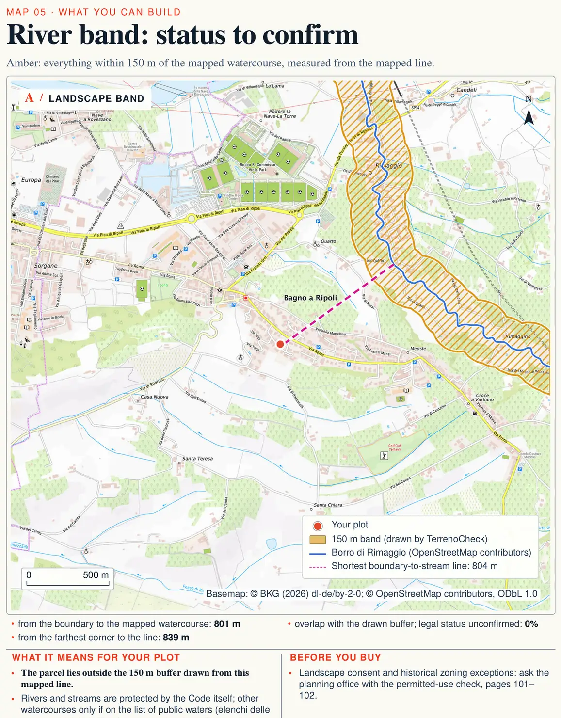
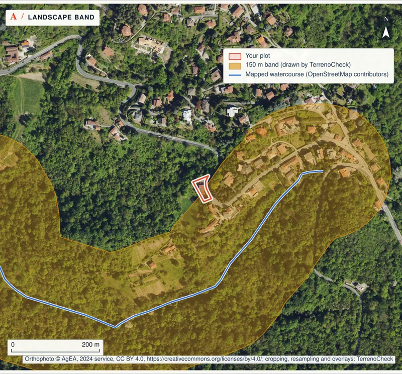
The law protects “rivers, streams and watercourses entered in the lists” of public waters, together with their banks or the foot of their embankments, for a strip of 150 metres on each side (Legislative Decree 42/2004, Article 142(1)(c)). An owner of protected land must submit the project and may not start work until landscape authorisation has been granted (Article 146(1) and (2)), except for the work exempted by Article 149, described below. Our guide to the vincolo paesaggistico explains how that procedure works.
The constraint does not cover everything within 150 metres. It excludes areas that on 6 September 1985 were zoned A or B in the town plan under the 1968 zoning decree (DM 1444/1968); areas in other zones included in multi-year implementation plans, provided those plans were actually carried out; and, in comuni without a plan, areas inside the built-up perimeter drawn under Article 18 of Law 865/1971 (Article 142(2)). It also excludes watercourses that the region has declared irrelevant to the landscape, in a public list sent to the Ministry, which may still confirm their importance (Article 142(3)).
Article 149 then lists work that needs no authorisation even inside the zone: routine and major maintenance, structural strengthening and conservative restoration that leave the land and the exterior of buildings unchanged (point a); farming and forestry work that does not permanently change the land with buildings or other civil works and does not affect the ground or the way water drains through it (point b); and routine felling, planting, drainage and fire-prevention work in protected woodland, where planned and authorised under the forestry rules (point c). Ploughing and pruning an olive grove can fall under point (b) if they meet both conditions; levelling or drainage work that changes how water runs off should be checked with the comune first; a farm shed, which is a building, is not covered.
Flood risk: the basin authority’s maps
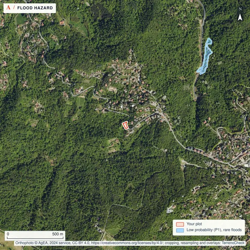
The 10 and 150 metre zones depend on distance; flooding depends on the lie of the land. A field 300 metres from a river can sit in a flood-prone area, while another 50 metres away but higher up may not. Flood risk management plans are prepared by the district river basin authorities from hazard and risk maps (Legislative Decree 49/2010, Article 7), and the rules on what may be built in each hazard class are in those plans.
How to read the hazard classes and where to find the maps is covered in our guide to PAI, flood and landslide risk. If the land is also under the hydrogeological constraint (vincolo idrogeologico), earthworks follow a separate procedure, explained in our guide to the hydrogeological constraint.
How to check before you buy
Run the checks in this order, before your offer or at the latest before the preliminary contract (compromesso). The zoning certificate can take up to 30 days, so ask for it first.
- Measure on the map (an hour, from home). On the cadastral map or a regional technical map, find the nearest watercourse and measure its distance from the boundary and from any buildings. Note whether it has embankments.
- Ask for the zoning certificate (up to 30 days, the comune’s planning office). The certificato di destinazione urbanistica (CDU) must be issued within a binding 30 days of the request and stays valid for a year if the plans do not change (DPR 380/2001, Article 30(3)). It shows the zone and the plan’s constraints; ask too whether the parcel lies in the 150 m zone and whether the exclusions in Article 142(2) apply.
- Write to the regional river control office (timing varies). Ask whether the watercourse is public, which distance applies on that stretch and which line it is measured from.
- If there is a canal, write to the drainage body. Ask for the distance for buildings and whether existing buildings are tolerated.
- Look at the basin authority’s flood maps. Note the parcel’s hazard class.
- Take it all to a technician. A geometra (surveyor) or architect compares the answers with what you plan to build and with the existing buildings.
Land near a river in Italy: the 10 m and 150 m zones and floods
https://terrenocheck.it/en/guide/river-buffer-zones-italy
Checklist
Before you make an offer on land near a watercourse
Common questions
How far from a river can I build a house in Italy?
For public watercourses the national rule is at least 10 m from the foot of the embankments for buildings and excavations, but only where the rules in force locally set no other distance (Royal Decree 523/1904, Article 96(f)). If the land really falls inside the 150 m band of a protected watercourse, a new house also needs landscape authorisation; Article 142(2) and (3) of Legislative Decree 42/2004 exclude some areas from the constraint, listed in the section on the landscape constraint, and the comune’s plan can add limits of its own. Ask the regional river control office and the comune which figure applies to that stretch.
Where are the 10 metres measured from if the stream has no embankment?
Article 96 only speaks of the distance from the foot of the embankments and their accessories. For a watercourse without embankments that article does not say which line to start from: ask the office in charge of river control for that stretch, in writing, before anything is designed.
Does the ditch along my boundary count?
It depends on what it is. If it is public water, Royal Decree 523/1904 applies; if it is a canal in a land-drainage district, Royal Decree 368/1904 applies, with 4 to 10 m for buildings; for minor watercourses the regions may have their own rules. The 150 m landscape zone covers rivers, streams and watercourses entered in the official lists of public waters.
Can I farm inside the 150 metre zone?
Yes. Landscape authorisation is not needed for farming, forestry and grazing work that does not permanently change the land with buildings or other civil works and does not affect the ground or the way water drains through it (Legislative Decree 42/2004, Article 149). A building, even a farm building, is not covered by that exclusion.
If the 150 metre constraint applies, can nothing be built?
Not necessarily. For work that is not exempt, the constraint means submitting the project and obtaining landscape authorisation before starting (Legislative Decree 42/2004, Article 146); what can be built depends on the comune’s plan and the outcome of that procedure. The 10 m river control zone, by contrast, is a ban.
Where can I see whether the land is at risk of flooding?
On the hazard and risk maps and in the flood risk management plan prepared by the district river basin authority (Legislative Decree 49/2010, Article 7). How to read them is covered in our guide to PAI, flood and landslide risk.
Keep reading
Vincolo paesaggistico: what it permits
PAI flood and landslide risk in Italy: before you buy
Buying land near a cemetery or a road in Italy: buffer zones and what is left to build on
The hydrogeological constraint (vincolo idrogeologico): what it stops, who approves works, and what to check on an existing house
Rivers, constraints and flood maps around the parcel
Pick the parcel on the map: nearby watercourses, the landscape band to confirm, and flood and landslide maps are read for that plot, each with a source and date, along with the questions to put to the comune and the region.
€29 in English or Italian · €39 in both languages · total, VAT included